While we were visiting Greenville, we were looking for Campbell’s Covered Bridge. While researching Campbell’s Covered Bridge, we heard about the remains of a historic stone bridge was located a short drive away. Having an interest in historic bridges we set off in search of the bridge.
Oldest Bridge in South Carolina
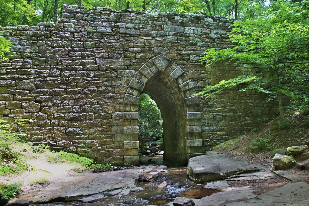
Poinsett Bridge, the oldest bridge in South Carolina, was completed in 1820. It was part of the original road connecting Greenville to Asheville. Some historians believe that the bridge was constructed by Robert Mills, the architect of the Washington Monument, U.S. Treasury Building and many significant South Carolina buildings. Poinsett Bridge was added to the National Register of Historic Places in 1970.
The Poinsett Bridge is located north of Greenville, South Carolina, just four or five miles away from the North Carolina state line.
Poinsett Bridge was one of three bridges constructed along the Saluda Mountain Road as part of the construction of the State Road which ran from Charleston through Columbia to North Carolina. Today
it is the only one of the three still in existence.
Poinsett Bridge was abandoned in 1955-1956 due to the realignment of County Road 42. In the late 1950s-early 1960s, the North Saluda Reservoir was established. The North Saluda River and Hodge’s Creek bridge sites were destroyed. Poinsett Bridge (formerly known as the Little Gap Creek Bridge) remained as the only survivor. The Saluda Mountain Road (the old State Road) and the Poinsett Bridge remained in use until at least 1955.
The Construction of the Poinsett Bridge
It was designed by Joel Roberts Poinsett in 1817-1819, then director of the South Carolina Board of Public Works. The stone bridge was named after Poinsett, a Charleston native. Poinsett was a prominent resident of early Greenville and served as a member of Congress and was the first United States ambassador to Mexico. The poinsettia flower, which Poinsett introduced to the United States from Mexico, was also named after him.
Abraham (Abram) Blanding, one of the two acting commissioners of the Board of Public
Works, was in charge of the day-to-day work done on the state’s roads, rivers, and canals. He directly supervised the construction of the Poinsett Bridge.
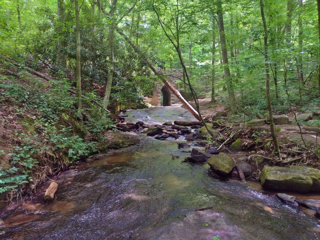
Poinsett Bridge is best known for its photogenic 14-foot Gothic arch, which is 15 feet high and 7 feet wide. The bridge spans 130 feet over Little Gap Creek. The stones used in the bridge are roughly hewn and a mortar was used throughout to ensure a good fit. The only smooth-faced stones found in the entire bridge are located at the outer edges of the arch.
The arch, which rests on bedrock in the streambed, is formed by rectangular-shaped blocks called voussoirs that are slightly wedge-shaped and specifically cut to fit precisely into the arch. These blocks are placed in an alternating pattern with one stone placed so that the long side faces outward and the following stone placed so that its long side faces the inside of the arch. The stones facing outward, which form an alternating pattern. This style is referred to as exaggerated voussoirs.
Stepped parapet walls were constructed on both sides of the bridge. The height of the bridge, from the water to the top of the parapets, is 24 feet. The date “1820” was initially chiseled into the keystone, but has faded away over the years.
Poinsett Bridge Today
There is a decent sized parking area right across the street from where the bridge is located. We walked across the street to the bridge, which isn’t visible from the road. You can go three directions from here.
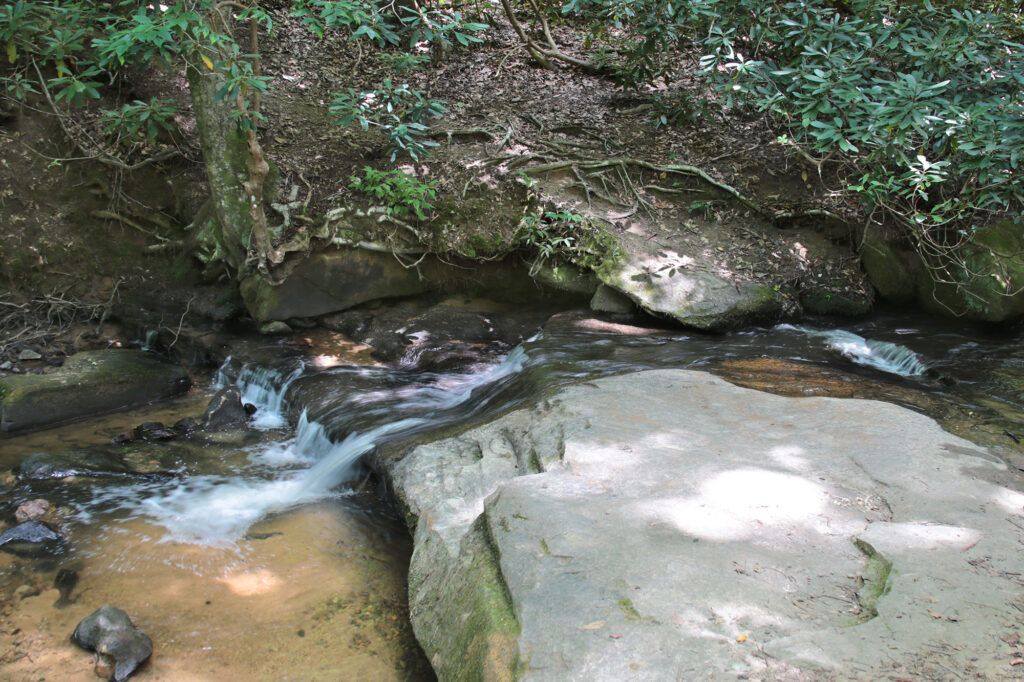
If you go to the right you’ll get to a small area where you can access a stream where we found kids splashing around in it on the hot afternoon. The stream that flows under Poinsett Bridge, which is now called Callahan Branch, is named after Gresham Callahan, whose family owned much of the land on both sides of the stream in the later 1800s.
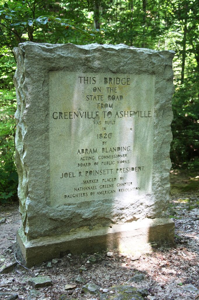
If you go straight you’ll cross over the top of the bridge which will take you to a walking trail that runs alongside of the stream. On the south side of the bridge there is a stone marker that reads, “This bridge on the state road from Greenville to Asheville was built in 1820 by Abram Blanding, Acting Commissioner, Board of Public Works, Joel R. Poinsett, President.” It was placed there by the Nathaniel Greene Chapter of the Daughters of the American Revolution.
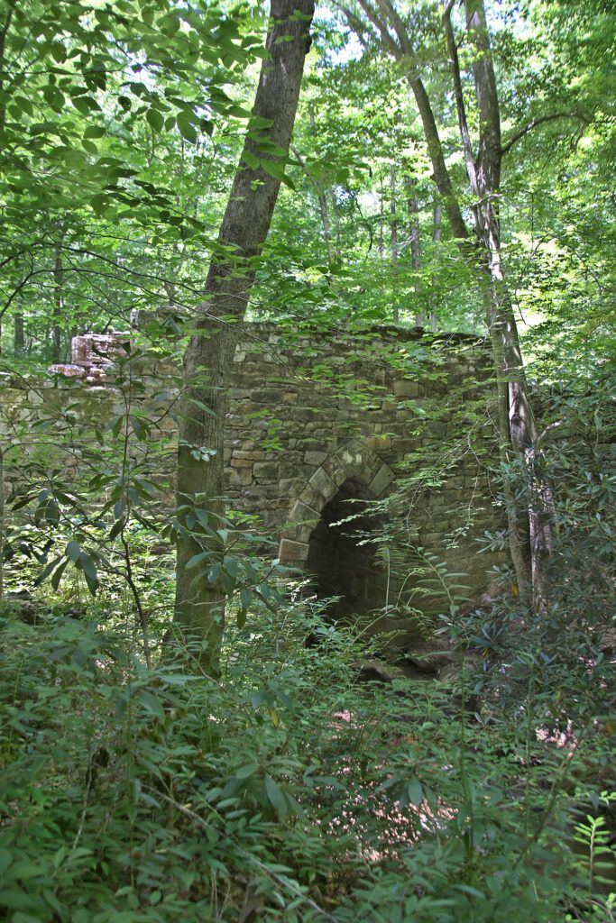
We crossed the bridge and headed down the trail. Peeking through the trees you can see what remains of Poinsett Bridge and its beautiful Gothic arch, which looks like it belongs on a medieval castle.
Wanting to get a closer look at the bridge, I walked through a shallow part of the stream over to the other side where I could walk back along the stream on the other side and head back toward the bridge.
There are lots of flat areas directly in front of the bridge where you can get great photographs. You can even walk through the arch itself.
We left by climbing up a pathway next to the bridge which brings you back up to the top of the bridge (this is the third way you can reach the bridge). This way requires you to navigate some large chunks of rocks, so if you have little kids you may want to pick a different way.
There are no restroom facilities located at Poinsett Bridge.
Poinsett Bridge Haunting Claims
The bridge has been featured in local ghost stories for decades. In 2019, Poinsett Bridge was named as one of the 30 most haunted places in America by the magazine Condé Nast Traveler.
During the construction of the bridge, many workers became ill with what historians believe to be malaria. According to local folklore, these men were then supposedly buried under and even within the bridge itself. Historical records does describe that many of the workers became sick with malaria even before they arrived in the mountains. Other locals claim that a number of men were killed by a great flash flood during the building of the bridge. It has never been confirmed that any remains were buried inside the Poinsett Bridge during the nearly four-month-long construction of the Poinsett Bridge.
Another story details two stonemasons with the surname of either Denny or Danny who were so proud of their work on the bridge that they come back to haunt it at night.
Some people say the ghosts of people who died during construction sometimes reappear as lights in the surrounding woods and on the bridge itself after dusk and hover for a few seconds before disappearing. Others have reported hearing screams echoing from under the bridge.
One claim is that a slave was killed at or near the Poinsett Bridge. One legend says that a slave was once hung under Poinsett Bridge and his ghost still haunts it today. A different version claims that a female slave was hung from the bridge. And yet still another describes a slave was beheaded near the bridge by his master.
Another local legend claims the headless body of a man who was shot on the bridge in 1861 returns on rainy nights exactly at the stroke of midnight.
According to local stories, the Poinsett Bridge was built on the site of an old Indian burial ground dating back to when Cherokees were the only inhabitants of the mountains of the Carolinas, Georgia, and Tennessee. However, historians document that the Cherokee typically buried their dead, indoors or near their homes, not in a large plot away from their homes. According to Thomas Mails, in his book The Cherokee People, “In each town there was a priest whose task it was to bury the dead. He came soon after death to the house where the corpse was and usually buried it either in the floor directly under the place where the person had died, under the hearth, outside near the house, or in the case of a distinguished chief, under the seat he had occupied in the town council house.” If this was the case it seems unlikely that they would have buried people in what is to be believed as their hunting grounds.
According to Cherokee traditions during that time those buried outdoors would be placed inside a “structure” between a large rock and a wall built opposite the rock. They would add a “roof” using an arch of stone or wood to cover over the tomb. Although at least if the bridge had been constructed over a burial site it would be similar to the Cherokees’ own burial traditions.
Many visitors have also reported having sudden and inexplicable car trouble when they try to leave.
Directions
Poinsett Bridge is located 2 miles northwest of SC Hwy 11. Turn onto old US Hwy 25. Travel 3.2 miles, then turn right onto Callahan Mountain Rd. Drive 2.2 miles and Poinsett Bridge will be on your left.
Leave a Reply