Southeast Waterfall & Hiking Guide

Your Hiking Guide to Waterfalls and more in the Southeast US

  • Home
  • About
  • Ease of Trail
    • Roadside
    • Wheelchair Accessible
    • Easy
    • Moderate
    • Strenuous/Hard
  • Fall Location
    • Georgia
    • North Carolina
    • South Carolina
    • Kentucky
    • Tennessee
    • Virginia
  • Waterfall Trips
    • Day Trip
    • 3 to 5 Day Trip
  • Area Attractions
    • Bridges
  • Hiking
  • Blog
    • News
    • Photography
  • Terms to Know
Home Trails Meadow Branch Cascades

Meadow Branch Cascades

Posted on March 14, 2025 Written by Leave a Comment

Nearby Areas: Great Smoky Mountains   State: Tennessee   Ease of Trail: Roadside

While on the way to Cades Cove, we decided to check out the nearby waterfalls and the Wye on our way.  Our third stop after visiting Cane Creek Twin Falls and Whiteoak Flats Branch Falls was Meadow Branch Cascades.

This waterfall isn’t the easiest to find, so I’d recommend you put it into your GPS to find it as it isn’t easy to see from the road. Meadow Branch Cascades is located on the right side of the road a few hundred yards before you reach the tunnel.

There is no parking by the waterfall so you’ll need to pass the waterfall and park about 1/4 mile further along Laurel Creek Road near the tunnel and then walk back following the West Prong Little River.

It’s really easy to miss seeing this waterfall because it’s on your right side as the road is curving to the left and you have to look down to see it. I knew this in advance, so I programmed the location into my GPS so I’d know when we were getting close, and then I had my son look for the waterfall as we passed. He has a great memory, so I knew he’d be able to find it on the way back. As we were walking back, he told me that you couldn’t miss seeing it. He was correct, and I was able to easily find it on our walk back.

You can view the waterfall from the side of the road. When we visited in February, it was easy to see the full waterfall from the road. There was a decent space along the side of the road here, so I felt safe taking the time to look at the waterfall for a few minutes.

I’m told there is a steep dirt path that leads downhill about 20 feet to the water’s edge where Meadow Branch Cascade is visible across the river but since we had a lot scheduled for the day and we could see the waterfall clearly from where we were at, we decided to keep going to Cades Cove.

While in the area, in addition to Cades Cove, we also checked out two other roadside waterfalls in addition to this waterfall that are located on the same road – Whiteoak Flats Branch Falls and Cane Creek Twin Falls. While none of these are really worth a special trip I do recommend checking them out since they are really close. This waterfall is best viewed in the winter and spring months or right after a good rain to have good water flow and to be visible through the trees.

If you are planning on visiting the national park for an extended period of time, please note that parking passes are required to park in the Great Smoky Mountains National Park for longer than 15 minutes. There’s a parking pass machine at the end of the parking area of the Wye (just down the road). The Wye is a great swimming hole in the summer and worth a visit. While it was too cold to swim when we visited in February, it was quite pretty.
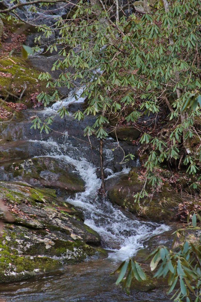
Meadow Branch Cascades

Share:

  • Share on Facebook (Opens in new window) Facebook
  • Share on X (Opens in new window) X
  • Share on WhatsApp (Opens in new window) WhatsApp
  • Share on Pinterest (Opens in new window) Pinterest
  • More
  • Share on Tumblr (Opens in new window) Tumblr
  • Share on Reddit (Opens in new window) Reddit
  • Print (Opens in new window) Print

Like this:

Like Loading…

Related

Directions

From Townsend: Head north on Mountain Avenue toward the Townsend Historical Trail. Turn right onto US-321/E. Lamar Alexander Parkway. Continue straight on the parkway. Continue through the Townsend entrance of the Great Smoky Mountains National Park. The road veers slightly left and becomes Old State Highway 73. Old State Highway 73 turns right and becomes Laurel Creek Road. The waterfall will be on the right side of the road a few hundred yards before you reach the tunnel. Pass the waterfall and park about 1/4 mile further along Laurel Creek Road near the tunnel and then backtrack following the West Prong Little River.

GPS Coordinates

To the Trailhead:35° 39.114'N, 83° 42.78'W

Nearby Areas: Great Smoky Mountains

State: Tennessee

Ease of Trail: Roadside

Leave a ReplyCancel reply

Recently Added Waterfalls

  • Bullpen Cove Falls
    State: North Carolina
    Trail Ease: Roadside
  • Buffalo Springs Falls
    State: Tennessee
    Trail Ease: Easy, Roadside
  • Glen Falls
    State: Tennessee
    Trail Ease: Moderate
  • Vickery Creek Falls/Dam
    State: Georgia
    Trail Ease: Easy
  • Waterfall Park (Dalton, GA)
    State: Georgia
    Trail Ease: Easy

Recently Added Trips

  • Rutledge Falls at the base
    Explore Ten Waterfalls In a Day In This Tennessee Waterfall Road Trip
  • The Sinks 2
    Smoky Mountain Roadside Waterfall Day Trip
  • Little Egypt Falls
    Wartburg Area Waterfall Day Trip
  • Rutledge Falls at the base
    Tullahoma Family Friendly Waterfall Day Trip
  • Lower Greeter Falls in the Spring
    South Central Tennessee 3-5 Day Trip
  • Full length of Pine Ridge Falls
    Erwin Area Waterfall Day Trip
  • Upper Falls Graveyard Fields
    Blue Ridge Parkway to Highlands Road Trip

Fall Trails by Difficulty

  • Easy (111 trails)
  • Moderate (43 trails)
  • Wheelchair Accessible (10 trails)
  • Roadside (43 trails)
  • Strenuous (9 trails)

Waterfalls by State

  • Georgia (8 trails)
  • South Carolina (9 trails)
  • North Carolina (48 trails)
  • Tennessee (76 trails)
  • Virginia (9 trails)
  • Kentucky (4 trails)

Copyright Info
Privacy Policy

Supporting the Site
Disclaimer & Info
About the Authors
Wesite developed by Waltdesign & Development.
%d