Southeast Waterfall & Hiking Guide

Your Hiking Guide to Waterfalls and more in the Southeast US

  • Home
  • About
  • Ease of Trail
    • Roadside
    • Wheelchair Accessible
    • Easy
    • Moderate
    • Strenuous/Hard
  • Fall Location
    • Georgia
    • North Carolina
    • South Carolina
    • Kentucky
    • Tennessee
    • Virginia
  • Waterfall Trips
    • Day Trip
    • 3 to 5 Day Trip
  • Area Attractions
    • Bridges
  • Hiking
  • Blog
    • News
    • Photography
  • Terms to Know
Home

Alvarado Road Falls

Posted on October 24, 2020 Written by Leave a Comment

Nearby Areas: Backbone Falls, Backbone Rock, Damascus, Mock's Mill Falls, Virginia Creeper Trail   State: Virginia   Ease of Trail: Roadside

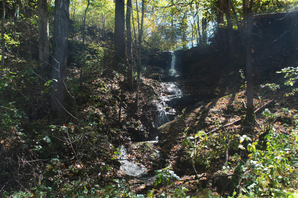
Alvarado Road Falls, while not impressive enough for a trip on its own, is fairly close to several other waterfalls and is located in a scenic area, however it is worth a visit if you are in the area. This waterfall is not widely known so you most likely will have it all to yourself.

This waterfall is not the easiest to photograph. You’ll want to visit either early in the morning or at dusk for the best photographic results. We unfortunately visited during the middle of the day.

Just 15 minutes away is the beautiful Backbone Falls and Backbone Rock just across the Tennessee border. In 1901, a tunnel was drilled through the rock to allow railroad access between Shady Valley and Damascus creating Backbone Rock, “The Shortest Tunnel in the World”. There’s lots of hiking opportunities in this area as well as a lake to picnic at. The Virginia Creeper Trail is nearby as well as a train exhibit in the parking area for the Creeper Trail in Damascus. And don’t forget to visit Mock’s Mill Falls in Damascus while you are there.

We also drove along the nearby US-58 to check out the sights as we visited in fall and the leaves were at peak, so we were treated with a beautiful array of color.

Share:

  • Click to share on Facebook (Opens in new window) Facebook
  • Click to share on X (Opens in new window) X
  • Click to share on WhatsApp (Opens in new window) WhatsApp
  • Click to share on Pinterest (Opens in new window) Pinterest
  • More
  • Click to share on Pocket (Opens in new window) Pocket
  • Click to share on Tumblr (Opens in new window) Tumblr
  • Click to share on Reddit (Opens in new window) Reddit
  • Click to print (Opens in new window) Print

Like this:

Like Loading...

Related

Directions

From Abingdon, VA, take US-58 east to SR-711. You'll see a sign that says "To 711." Turn right onto this road. Just past a bridge and the road becomes SR-711. Take this road for 0.6 miles to the waterfall. Watch your mileage as it is easy to pass the waterfall. Just before the waterfall there is a fork in the road. Go right downhill and the waterfall will be on the left side of the road. Parking is very limited. Just before the guardrail there is a small pulloff on the right. If this is full or you pass the pulloff, you can turn around and park on the waterfall side (however there's only room for one vehicle).

GPS Coordinates

To the Waterfall:36.6428 N, 81.8472 W

Nearby Areas: Backbone Falls, Backbone Rock, Damascus, Mock's Mill Falls, Virginia Creeper Trail

State: Virginia

Ease of Trail: Roadside

Leave a ReplyCancel reply

Recently Added Waterfalls

  • Meadow Branch Cascades
    Meadow Branch Cascades
    State: Tennessee
    Trail Ease: Roadside
  • Whiteoak Flats Branch Falls
    Whiteoak Flats Branch Falls
    State: Tennessee
    Trail Ease: Roadside
  • Twin Falls
    Cane Creek Twin Falls
    State: Tennessee
    Trail Ease: Easy, Roadside
  • Machine Falls
    Machine Falls
    State: Tennessee
    Trail Ease: Easy, Moderate
  • Rutledge Falls at the base
    Rutledge Falls
    State: Tennessee
    Trail Ease: Easy

Recently Added Trips

  • The Sinks 2
    Smoky Mountain Roadside Waterfall Day Trip
  • Little Egypt Falls
    Wartburg Area Waterfall Day Trip
  • Rutledge Falls at the base
    Tullahoma Family Friendly Waterfall Day Trip
  • Lower Greeter Falls in the Spring
    South Central Tennessee 3-5 Day Trip
  • Full length of Pine Ridge Falls
    Erwin Area Waterfall Day Trip
  • Upper Falls Graveyard Fields
    Blue Ridge Parkway to Highlands Road Trip
  • City Lake Falls
    Southeast Tennessee: Cookeville to Tellico Plains 3-5 Day Waterfall Road Trip

Fall Trails by Difficulty

  • Easy (103 trails)
  • Moderate (42 trails)
  • Wheelchair Accessible (9 trails)
  • Roadside (40 trails)
  • Strenuous (9 trails)

Waterfalls by State

  • Georgia (5 trails)
  • South Carolina (9 trails)
  • North Carolina (47 trails)
  • Tennessee (71 trails)
  • Virginia (8 trails)
  • Kentucky (4 trails)

Copyright Info
Privacy Policy

Supporting the Site
Disclaimer & Info
About the Authors
Wesite developed by Waltdesign & Development.
%d