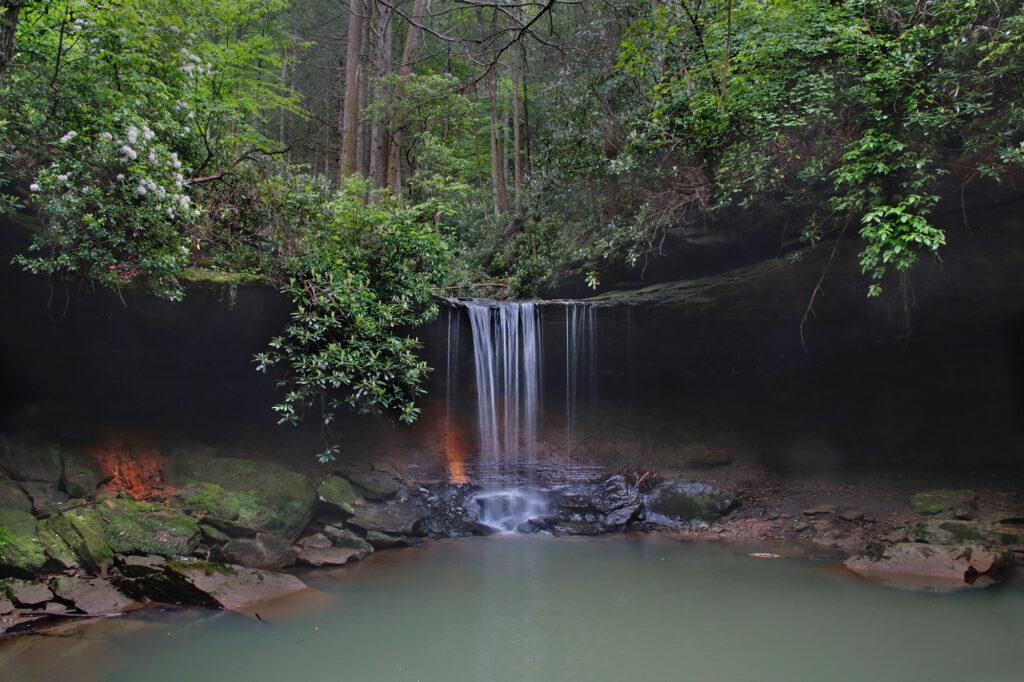
While Amos Falls isn’t the biggest waterfall, it has a lot going for it. Located in the Daniel Boone National Forest, this 16 foot tall, 14 feet wide, is very picturesque. The background behind the waterfall is interesting and almost looks like it’s lit up with colored lights in the photos we took. In fact, when we first saw photos of it, with thought it was an interesting light reflection, but it’s actually the color of the ground and side walls.
Driving to the Fall Parking Area
This waterfall is not the easiest to locate or to get to, so if you do visit, you most likely won’t encounter very many other people along the way. The GPS gets a little confused when going to Amos Falls. We put in coordinates 36.82615° N, 84.25808° to the parking area when we visited. When you get to Ova Lane, the paved road will continue to the right. You’ll need to take the gravel road that keeps going straight.
This road is not maintained and I wouldn’t recommend driving it in a vehicle with low clearance. Not only was it rough, there were many pot holes that could swallow a small child. My husband drove slowly navigating around them, as there was water in several so we couldn’t tell how deep they actually were.
The Trail to the Waterfall
The trailhead is not marked by signs, so you will need to look for it. It is located on the left side of the road about 1 mile from where the gravel begins. As you approach the 1 mile point, look for a parking area on the shoulder of the road near a large tree that sometimes has caution tape tied to the trunk of the tree. When we were there, there was no caution tape, so someone might want to go back and add some. We didn’t bring any, not knowing it needed to be remarked.
I would recommend a hiking stick, especially if hiking this trail after a good rain. We forgot ours, but we were fortunate that The Shadow Hiker left a walking stick at the trailhead. (Thank you kind person, this really helped, especially in the wet conditions.)
This wet season waterfall almost completely dries up in the Summer, so we visited in the Spring to ensure good water flow. However, with good water flow comes slippery trail conditions. This trail is extremely slippery after a lot of rain (and it had rained almost all week before we got there), especially since it not only has slopes that go up and down but also the trail itself seems to tilt from side to side in some sections. The nice thing is, for most of the trail, it didn’t have a lot of elevation change from section to section, so it doesn’t require a skilled hiker to navigate to.
I would strongly recommend hiking this in jeans, or something with a strong pants material. We found several thorny bushes and vines along the trail, and knew it would be rough on our legs if they were not properly protected.
The trail is very easy to follow and is marked by hanging markers/streamers along the way. It gets very narrow in parts. The trail winds around and takes you to the base of the waterfall. Right before you get to the base, you’ll hike downward, which can be slippery after a good rain. Take it slow and steady, and you will be fine though.
The Waterfall Itself
The waterfall has an interesting composition spilling over a ledge into a pool. There’s forest above the ledge and around the sides it’s almost cave-like. The sides of the waterfall have interesting streaks on the wall.
You can walk around closer to the waterfall on the right-hand side, but be careful. It is extremely slippery if it is wet or muddy.
We had the waterfall all to ourselves, so we were able to look around and explore a little. The pool of water at the base of the waterfall was fairly shallow, and it wasn’t very clean, so this isn’t the best place to swim. However, it was very peaceful.
Once you’ve enjoyed the waterfall, return to the parking area the way you came. It was a little bit challenging climbing uphill to return to the parking area on the slippery trail, but totally doable.
When we arrived back at the beginning of the trail, we returned the hiking stick for someone else to use.
Things to bring when hiking to Amos Falls – hiking pole, extra pair of socks (if wet conditions), something to wipe off your shoes or a change of shoes (if wet conditions), and water.
There are many waterfalls in the area. So while in the area, be sure to visit Cumberland Falls, Eagle Falls, Dog Slaughter Falls, Yahoo Falls, and Princess Falls.
Leave a Reply