Southeast Waterfall & Hiking Guide

Your Hiking Guide to Waterfalls and more in the Southeast US

  • Home
  • About
  • Ease of Trail
    • Roadside
    • Wheelchair Accessible
    • Easy
    • Moderate
    • Strenuous/Hard
  • Fall Location
    • Georgia
    • North Carolina
    • South Carolina
    • Kentucky
    • Tennessee
    • Virginia
  • Waterfall Trips
    • Day Trip
    • 3 to 5 Day Trip
  • Area Attractions
    • Bridges
  • Hiking
  • Blog
    • News
    • Photography
  • Terms to Know
Home

Big Falls (inside Pinnacle Natural Area Preserve)

Posted on March 21, 2021 Written by Leave a Comment

Nearby Areas: Abingdon, Lebanon, Pinnacle Natural Area Preserve, Spring Falls   State: Virginia   Ease of Trail: Easy

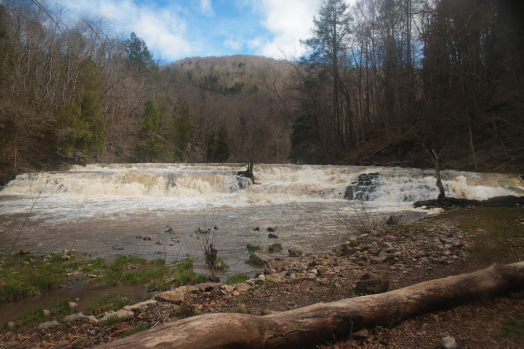
While only 12 feet high, Big Falls remains impressive due to its width. It spreads from bank-to-bank cascading over sandstone steps.  Big Falls is located inside the Pinnacle Natural Area Preserve.

From the good sized parking lot, you will start your hike by walking up steps and crossing a suspension bridge. It swings pretty easily, especially if you have kids with you.

Upon crossing you will be on the Big Cedar Creek Trail, which starts out pretty narrow, but widens to become a large gravel covered trail. The trail takes you alongside Big Cedar Creek almost the entire way. Please note that after prolonged heavy rains the trail can flood at the beginning, as had occurred on our trip. However, we were able to climb alongside the trail and still pass.

At 0.4 miles the Big Cedar Creek Trail intersects with the Grapevine Hill Trail on your left. Continue straight on the wide blue-blazed trail continuing alongside the creek.

In another half-mile, you’ll see a second trail junction with a large preserve map sign. There is also a post behind it with the trail names and blaze colors with the distance to each trail from this point. Up ahead you will see pit toilets and a picnic shelter. However, you will want to turn left at the junction and head uphill to continue on the Big Cedar Creek Trail that will lead you to Big Falls.

The creek becomes more dramatic in this section leading you to the center of the preserve and Big Falls. A small side trail will take you down a few yards to the base of the falls.

We chose to turn around at this point to head back to Spring Falls (also located in Pinnacle Natural Area Preserve), but the Pinnacle View Trail (the namesake of the preserve) is just a little bit further down the trail. To view the Pinnacle, continue down the Big Cedar Creek Trail to another trail junction at approximately1.4 miles. The main trail heads to the left here, while the Pinnacle View Trail forks off to the right.

If you wish to complete your hike without viewing the Pinnacle, simply return the way you came on the Big Cedar Creek Trail.

To view Spring Falls after viewing Big Falls, head back the way you came until you get to the trail junction. Turn right to return to the parking lot or turn left to view Spring Falls, which is located just behind the picnic shelter. Follow the green blazed trail to Spring Falls, which is an easy 0.25 mile hike.


Big Falls located in Pinnacle Natural Area Preserve


Share:

  • Click to share on Facebook (Opens in new window) Facebook
  • Click to share on X (Opens in new window) X
  • Click to share on WhatsApp (Opens in new window) WhatsApp
  • Click to share on Pinterest (Opens in new window) Pinterest
  • More
  • Click to share on Pocket (Opens in new window) Pocket
  • Click to share on Tumblr (Opens in new window) Tumblr
  • Click to share on Reddit (Opens in new window) Reddit
  • Click to print (Opens in new window) Print

Like this:

Like Loading...

Related

Directions

From I-81 in Abingdon, take Alt 58 West to U.S. Route 19 North. Go about 20 miles and get off at the Business 19 exit into Lebanon. Turn left. At the second light, turn left onto Route 82 West. Go 1.1 miles to Route 640 (River Mountain Road) and turn right. Go 4.2 miles and turn left on Route 721 (gravel road). Go 0.8 mile to the parking area on the left.

GPS Coordinates

To the Trailhead:36.95356, -82.05475

Nearby Areas: Abingdon, Lebanon, Pinnacle Natural Area Preserve, Spring Falls

State: Virginia

Ease of Trail: Easy

Leave a ReplyCancel reply

Recently Added Waterfalls

  • Meadow Branch Cascades
    Meadow Branch Cascades
    State: Tennessee
    Trail Ease: Roadside
  • Whiteoak Flats Branch Falls
    Whiteoak Flats Branch Falls
    State: Tennessee
    Trail Ease: Roadside
  • Twin Falls
    Cane Creek Twin Falls
    State: Tennessee
    Trail Ease: Easy, Roadside
  • Machine Falls
    Machine Falls
    State: Tennessee
    Trail Ease: Easy, Moderate
  • Rutledge Falls at the base
    Rutledge Falls
    State: Tennessee
    Trail Ease: Easy

Recently Added Trips

  • The Sinks 2
    Smoky Mountain Roadside Waterfall Day Trip
  • Little Egypt Falls
    Wartburg Area Waterfall Day Trip
  • Rutledge Falls at the base
    Tullahoma Family Friendly Waterfall Day Trip
  • Lower Greeter Falls in the Spring
    South Central Tennessee 3-5 Day Trip
  • Full length of Pine Ridge Falls
    Erwin Area Waterfall Day Trip
  • Upper Falls Graveyard Fields
    Blue Ridge Parkway to Highlands Road Trip
  • City Lake Falls
    Southeast Tennessee: Cookeville to Tellico Plains 3-5 Day Waterfall Road Trip

Fall Trails by Difficulty

  • Easy (103 trails)
  • Moderate (42 trails)
  • Wheelchair Accessible (9 trails)
  • Roadside (40 trails)
  • Strenuous (9 trails)

Waterfalls by State

  • Georgia (5 trails)
  • South Carolina (9 trails)
  • North Carolina (47 trails)
  • Tennessee (71 trails)
  • Virginia (8 trails)
  • Kentucky (4 trails)

Copyright Info
Privacy Policy

Supporting the Site
Disclaimer & Info
About the Authors
Wesite developed by Waltdesign & Development.
%d