Southeast Waterfall & Hiking Guide

Your Hiking Guide to Waterfalls and more in the Southeast US

  • Home
  • About
  • Ease of Trail
    • Roadside
    • Wheelchair Accessible
    • Easy
    • Moderate
    • Strenuous/Hard
  • Fall Location
    • Georgia
    • North Carolina
    • South Carolina
    • Kentucky
    • Tennessee
    • Virginia
  • Waterfall Trips
    • Day Trip
    • 3 to 5 Day Trip
  • Area Attractions
    • Bridges
  • Hiking
  • Blog
    • News
    • Photography
  • Terms to Know
Home

Bridal Veil Falls (NC)

Posted on September 1, 2017 Written by 2 Comments

Nearby Areas: Cashiers, Franklin, Highlands, Nantahala National Forest   State: North Carolina   Ease of Trail: Easy, Roadside

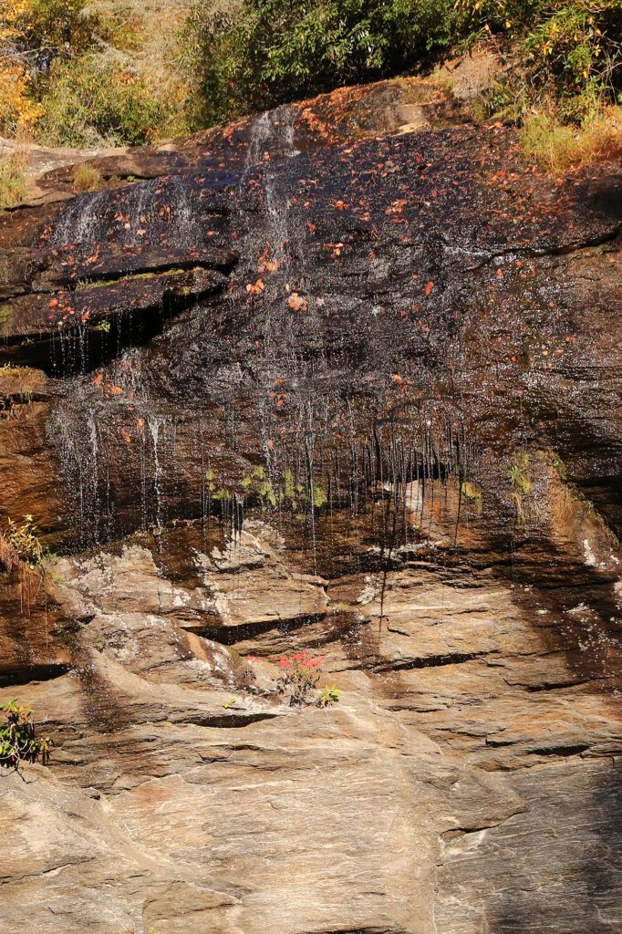
For many generations Bridal Veil Falls, which is located in the Nantahala National Forest, has been famous for being the only waterfall in North Carolina you can drive behind. When the highway was originally built, all traffic went behind the waterfall. There have always been problems with falling rocks and icy roads, however it has been decided to close off the section of road behind the waterfall from cars driving behind the waterfall for safety. There’s parking on each side of the waterfall, if you want to walk behind Bridal Veil Falls.

Although Bridal Veil Falls, is 60 feet tall, it doesn’t have much water flow unless it has rained a lot. After a heavy rain, the water flow increases which is the best time to view Bridal Veil Falls. It is located in the Cullasaja River Gorge on US Highway 64, also known as the Mountain Waters Scenic Byway/NC Waterfall Byway, just 2.5 miles west of Highlands.

I wouldn’t recommend a trip just to see this waterfall, however I would check it out if I were already in the area viewing other waterfalls. Dry Falls, Cullasaja Falls and Quarry Falls are also nearby and are definitely worth a visit.

Close up of Bridal Veil Falls in Highlands, NC
Close up of Bridal Veil Falls, in Highlands, NC, during the Fall. This waterfall is best viewed in the Spring.

Share:

  • Click to share on Facebook (Opens in new window) Facebook
  • Click to share on X (Opens in new window) X
  • Click to share on WhatsApp (Opens in new window) WhatsApp
  • Click to share on Pinterest (Opens in new window) Pinterest
  • More
  • Click to share on Pocket (Opens in new window) Pocket
  • Click to share on Tumblr (Opens in new window) Tumblr
  • Click to share on Reddit (Opens in new window) Reddit
  • Click to print (Opens in new window) Print

Like this:

Like Loading...

Related

Directions

From downtown Highlands at the intersection of Highways 28, drive US Highway 64 west (toward Franklin) for 2.3 miles and the parking area on your right. From Franklin (intersection of US 64 East and US 23/441), drive US 64 east towards Highlands for 14.5 miles.

GPS Coordinates

To the Waterfall:35.071864, -83.228959

Nearby Areas: Cashiers, Franklin, Highlands, Nantahala National Forest

State: North Carolina

Ease of Trail: Easy, Roadside

Comments

  1. Jaci says

    September 8, 2017 at 7:04 AM

    Fantastic Blog. Very much enjoyed reading.

    Reply
  2. Clarice says

    September 25, 2017 at 6:39 PM

    That’s such a shame that you can’t drive behind the waterfall anymore. I remember going with my family as a kid and driving behind it. That was so cool!

    Reply

Leave a ReplyCancel reply

Recently Added Waterfalls

  • Logan Creek Falls (also known as Falls Of Logan Creek)
    State: Virginia
    Trail Ease: Easy
  • Meadow Branch Cascades
    Meadow Branch Cascades
    State: Tennessee
    Trail Ease: Roadside
  • Whiteoak Flats Branch Falls
    Whiteoak Flats Branch Falls
    State: Tennessee
    Trail Ease: Roadside
  • Twin Falls
    Cane Creek Twin Falls
    State: Tennessee
    Trail Ease: Easy, Roadside
  • Machine Falls
    Machine Falls
    State: Tennessee
    Trail Ease: Easy, Moderate

Recently Added Trips

  • The Sinks 2
    Smoky Mountain Roadside Waterfall Day Trip
  • Little Egypt Falls
    Wartburg Area Waterfall Day Trip
  • Rutledge Falls at the base
    Tullahoma Family Friendly Waterfall Day Trip
  • Lower Greeter Falls in the Spring
    South Central Tennessee 3-5 Day Trip
  • Full length of Pine Ridge Falls
    Erwin Area Waterfall Day Trip
  • Upper Falls Graveyard Fields
    Blue Ridge Parkway to Highlands Road Trip
  • City Lake Falls
    Southeast Tennessee: Cookeville to Tellico Plains 3-5 Day Waterfall Road Trip

Fall Trails by Difficulty

  • Easy (104 trails)
  • Moderate (42 trails)
  • Wheelchair Accessible (9 trails)
  • Roadside (40 trails)
  • Strenuous (9 trails)

Waterfalls by State

  • Georgia (5 trails)
  • South Carolina (9 trails)
  • North Carolina (47 trails)
  • Tennessee (71 trails)
  • Virginia (9 trails)
  • Kentucky (4 trails)

Copyright Info
Privacy Policy

Supporting the Site
Disclaimer & Info
About the Authors
Wesite developed by Waltdesign & Development.
%d