Southeast Waterfall & Hiking Guide

Your Hiking Guide to Waterfalls and more in the Southeast US

  • Home
  • About
  • Ease of Trail
    • Roadside
    • Wheelchair Accessible
    • Easy
    • Moderate
    • Strenuous/Hard
  • Fall Location
    • Georgia
    • North Carolina
    • South Carolina
    • Kentucky
    • Tennessee
    • Virginia
  • Waterfall Trips
    • Day Trip
    • 3 to 5 Day Trip
  • Area Attractions
    • Bridges
  • Hiking
  • Blog
    • News
    • Photography
  • Terms to Know
Home

Connestee Falls

Posted on March 29, 2016 Written by 3 Comments

Nearby Areas: Brevard   State: North Carolina   Ease of Trail: Easy, Wheelchair Accessible

Connestee FallsConnestee Falls and its twin, Batson Creek Falls are located in Brevard, North Carolina.  Connestee Falls was supposedly named after an Indian princess named Connestee who lost her life at the waterfall due to her relationship with an Englishman.

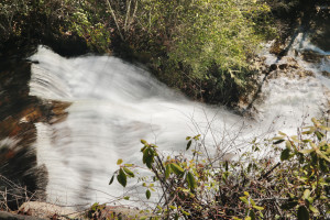
Connestee Falls is a 85 foot tiered waterfall. It flows from  Batson Creek. The waterfall is located where Batson Creek and Carson Creek meet, called the Silver Slip and continues down to Carson Creek.

Connestee Falls can be seen from a wheelchair accessible platform, built in 2011. You follow a short walkway from the rear of the parking lot next to of Top of the Falls Realty to the waterfall. From the platform if you go to the far side, you will see the top of Connestee Falls. Unfortunately this is the only view currently available of Connestee Falls.

There used to be a pathway going down for a better view of the falls, but it has been blocked and a no trespassing sign has been added. There is another viewing area next to Batson Creek Falls on private property.  You need to know someone who lives in Connestee Falls Development to use this viewing area.

The best times to view Connestee Falls is early morning or dusk. When the sun is high in the sky it creates shadows and hot spots on the waterfall. A tripod and polarizing filter are recommended when photographing this waterfall.

Batson Creek Falls  is the fanned cascade on the opposite side of the from the platform, which is located straight in front of  you.

This waterfall is very impressive, however given the view available to the average person (which isn’t very good), I gave it a lower rating.

Share:

  • Click to share on Facebook (Opens in new window) Facebook
  • Click to share on X (Opens in new window) X
  • Click to share on WhatsApp (Opens in new window) WhatsApp
  • Click to share on Pinterest (Opens in new window) Pinterest
  • More
  • Click to share on Pocket (Opens in new window) Pocket
  • Click to share on Tumblr (Opens in new window) Tumblr
  • Click to share on Reddit (Opens in new window) Reddit
  • Click to print (Opens in new window) Print

Like this:

Like Loading...

Related

Directions

From Brevard: Get on Hwy 276 south in the center of downtown Brevard, drive just under 6 miles and look for the Connestee Falls Park sign on the right adjacent to a log cabin. The parking lot for Top of the Falls Realty is also here. If you miss the 1st turn for the parking area, there's another one a short distance down. The trailhead and beginning of the walkway is marked by a sign at the far right right of the parking lot in the back.

GPS Coordinates

To the Trailhead:N35.1653, W-82.7310

Nearby Areas: Brevard

State: North Carolina

Ease of Trail: Easy, Wheelchair Accessible

Comments

  1. Marcy says

    October 17, 2016 at 2:38 AM

    I loved reading the background about this waterfall. It is always fun to learn something extra about the waterfall. It adds more to it than just the beauty of the waterfall itself. Thank you for the information!

    Reply
  2. Minnie says

    February 27, 2017 at 10:46 AM

    I love how you included information about how the waterfall got its name. It is always fun learning about the history behind the waterfall as well as looking at its beauty. It just enhances the experience. Thanks for the info!

    Reply
  3. Audrey Gerney says

    September 19, 2019 at 9:02 AM

    Nice post, wonderful website, keep up the good work.

    Reply

Leave a ReplyCancel reply

Recently Added Waterfalls

  • Logan Creek Falls (also known as Falls Of Logan Creek)
    State: Virginia
    Trail Ease: Easy
  • Meadow Branch Cascades
    Meadow Branch Cascades
    State: Tennessee
    Trail Ease: Roadside
  • Whiteoak Flats Branch Falls
    Whiteoak Flats Branch Falls
    State: Tennessee
    Trail Ease: Roadside
  • Twin Falls
    Cane Creek Twin Falls
    State: Tennessee
    Trail Ease: Easy, Roadside
  • Machine Falls
    Machine Falls
    State: Tennessee
    Trail Ease: Easy, Moderate

Recently Added Trips

  • The Sinks 2
    Smoky Mountain Roadside Waterfall Day Trip
  • Little Egypt Falls
    Wartburg Area Waterfall Day Trip
  • Rutledge Falls at the base
    Tullahoma Family Friendly Waterfall Day Trip
  • Lower Greeter Falls in the Spring
    South Central Tennessee 3-5 Day Trip
  • Full length of Pine Ridge Falls
    Erwin Area Waterfall Day Trip
  • Upper Falls Graveyard Fields
    Blue Ridge Parkway to Highlands Road Trip
  • City Lake Falls
    Southeast Tennessee: Cookeville to Tellico Plains 3-5 Day Waterfall Road Trip

Fall Trails by Difficulty

  • Easy (104 trails)
  • Moderate (42 trails)
  • Wheelchair Accessible (9 trails)
  • Roadside (40 trails)
  • Strenuous (9 trails)

Waterfalls by State

  • Georgia (5 trails)
  • South Carolina (9 trails)
  • North Carolina (47 trails)
  • Tennessee (71 trails)
  • Virginia (9 trails)
  • Kentucky (4 trails)

Copyright Info
Privacy Policy

Supporting the Site
Disclaimer & Info
About the Authors
Wesite developed by Waltdesign & Development.
%d