Southeast Waterfall & Hiking Guide

Your Hiking Guide to Waterfalls and more in the Southeast US

  • Home
  • About
  • Ease of Trail
    • Roadside
    • Wheelchair Accessible
    • Easy
    • Moderate
    • Strenuous/Hard
  • Fall Location
    • Georgia
    • North Carolina
    • South Carolina
    • Kentucky
    • Tennessee
    • Virginia
  • Waterfall Trips
    • Day Trip
    • 3 to 5 Day Trip
  • Area Attractions
    • Bridges
  • Hiking
  • Blog
    • News
    • Photography
  • Terms to Know
Home

Cullasaja Falls

Posted on September 4, 2022 Written by 1 Comment

Nearby Areas: Franklin, Highlands, Nantahala National Forest   State: North Carolina   Ease of Trail: Easy, Roadside

Cullasaja Falls and Cascade
Cullasaja Falls and Cullasaja Cascade

Cullasaja Falls is located in southwestern North Carolina in the Nantahala National Forest. Cullasaja Falls is on the Cullasaja River and is part of the Mountain Waters Scenic Byway. The waterfall is the last major waterfall on the Cullasaja River. Cullasaja comes from a Cherokee word meaning “honey locust place”.

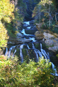
The height for this impressive waterfall has been disputed with ranges from 137 feet to 250 feet. Google Earth lists the height at 137 feet, based on the elevation of the water at the top of the falls and the elevation of the plunge pool at the bottom of the falls. I, like most people, included the cascade height with the waterfall height to give the height of 250 feet since the cascades look like they are part of the waterfall.

Top of Cullasaja Falls and Cascade

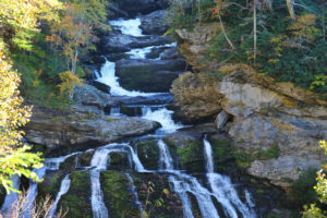
You can see Cullasaja Falls at a distance from US 64 while driving by. The waterfall is located beside of a series of blind curves, with sheer rock cliffs above and below the road.

You usually pass it before you realize where it is and drive past the small pull-off (can only fit 2-3 cars) and wind up turning around or parking and walking back alongside of the road. Sometimes the pull-off is full and you have to go to the next one and walk back any way. Please use extreme caution when walking back since this road is very busy and there is not much space next to the road to walk in.

Cullasaja Rapids
Nearby Cullasaja Rapids

Cullasaja Falls are best viewed in the winter and early spring to avoid the bottom part of the waterfall being obscured by tree growth in front of the waterfall.

There are several waterfalls nearby that you may want to check out while you are in the area including Dry Falls, Quarry Falls and Bridal Veil Falls.

Share:

  • Click to share on Facebook (Opens in new window) Facebook
  • Click to share on X (Opens in new window) X
  • Click to share on WhatsApp (Opens in new window) WhatsApp
  • Click to share on Pinterest (Opens in new window) Pinterest
  • More
  • Click to share on Pocket (Opens in new window) Pocket
  • Click to share on Tumblr (Opens in new window) Tumblr
  • Click to share on Reddit (Opens in new window) Reddit
  • Click to print (Opens in new window) Print

Like this:

Like Loading...

Related

Directions

In Franklin: From the intersection of Hwy 441 and 64 east, turn onto 64 and go east for about 7.7 miles.

GPS Coordinates

To the Waterfall:35.116397°N, 83.269527°W

Nearby Areas: Franklin, Highlands, Nantahala National Forest

State: North Carolina

Ease of Trail: Easy, Roadside

Comments

  1. Owen says

    December 1, 2016 at 7:42 PM

    I’ve been in this area before and never realized this waterfall was there. Now that I know where it is thanks to your directions. I’ll look for it next time I’m out there.

    Reply

Leave a ReplyCancel reply

Recently Added Waterfalls

  • Logan Creek Falls (also known as Falls Of Logan Creek)
    State: Virginia
    Trail Ease: Easy
  • Meadow Branch Cascades
    Meadow Branch Cascades
    State: Tennessee
    Trail Ease: Roadside
  • Whiteoak Flats Branch Falls
    Whiteoak Flats Branch Falls
    State: Tennessee
    Trail Ease: Roadside
  • Twin Falls
    Cane Creek Twin Falls
    State: Tennessee
    Trail Ease: Easy, Roadside
  • Machine Falls
    Machine Falls
    State: Tennessee
    Trail Ease: Easy, Moderate

Recently Added Trips

  • The Sinks 2
    Smoky Mountain Roadside Waterfall Day Trip
  • Little Egypt Falls
    Wartburg Area Waterfall Day Trip
  • Rutledge Falls at the base
    Tullahoma Family Friendly Waterfall Day Trip
  • Lower Greeter Falls in the Spring
    South Central Tennessee 3-5 Day Trip
  • Full length of Pine Ridge Falls
    Erwin Area Waterfall Day Trip
  • Upper Falls Graveyard Fields
    Blue Ridge Parkway to Highlands Road Trip
  • City Lake Falls
    Southeast Tennessee: Cookeville to Tellico Plains 3-5 Day Waterfall Road Trip

Fall Trails by Difficulty

  • Easy (104 trails)
  • Moderate (42 trails)
  • Wheelchair Accessible (9 trails)
  • Roadside (40 trails)
  • Strenuous (9 trails)

Waterfalls by State

  • Georgia (5 trails)
  • South Carolina (9 trails)
  • North Carolina (47 trails)
  • Tennessee (71 trails)
  • Virginia (9 trails)
  • Kentucky (4 trails)

Copyright Info
Privacy Policy

Supporting the Site
Disclaimer & Info
About the Authors
Wesite developed by Waltdesign & Development.
%d