Southeast Waterfall & Hiking Guide

Your Hiking Guide to Waterfalls and more in the Southeast US

  • Home
  • About
  • Ease of Trail
    • Roadside
    • Wheelchair Accessible
    • Easy
    • Moderate
    • Strenuous/Hard
  • Fall Location
    • Georgia
    • North Carolina
    • South Carolina
    • Kentucky
    • Tennessee
    • Virginia
  • Waterfall Trips
    • Day Trip
    • 3 to 5 Day Trip
  • Area Attractions
    • Bridges
  • Hiking
  • Blog
    • News
    • Photography
  • Terms to Know
Home

Debord Falls

Posted on July 7, 2023 Written by Leave a Comment

Nearby Areas: Emory Gap Falls, Lower Potters Falls, Potters Falls, Wartburg   State: Tennessee   Ease of Trail: Easy

Debord Falls is one of those waterfalls best viewed after a good rain or during early spring. To reach Debord Falls drive into the entrance to Frozen Head State Park and take the road until it dead ends into the parking lot for the Panther Branch Trail.

The trail is wide, but has some rocky and rooty parts. There is a creek near the beginning of the trail, if the water is low here, it will be low at Debord Falls. Right away, the trail crosses the Flat Fork on a concrete bridge and continues following it. Most of the small tributaries have  wooden bridges to cross over on this section of the trail. At 0.6 miles, you will reach the short side trail leading to Debord Falls. Go to the right to view the falls.

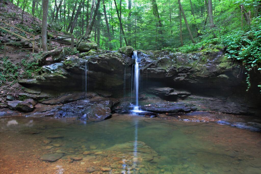
It will bring you to an observation deck view of the falls. After passing the observation deck, you will see a wooden staircase on your right that descends to the base of the falls.

After viewing Debord Falls return to the main trail, return the way you came to reach the parking lot.

When we visited Debord Falls there had been some recent rain, but apparently not enough and the water flow was low. The park ranger told us that if the water was low at Debord Falls, then it would be even lower at Emory Gap Falls and that it may not be worth the extra hike unless you just wanted to hike. We elected to return to the parking lot.

Should you want to continue on to view Emory Gap Falls, returned to the main trail and continue another 0.7 miles until you reach the junction of Panther Branch trail and the Emory Gap spur trail. At this junction make sure to take the Emory Gap trail straight, and not go over the bridge to your right. From here it is another 0.5 miles to Emory Gap Falls.

Please note that there is a lot of mosquitos in this park. It is also common to see copperhead snakes and woodland rattlers.

There are restrooms located at the park office at 964 Flat Fork Road, Wartburg, TN 37887.

Other nearby waterfalls include Potter’s Falls and Lower Potter’s Falls. They are not much of a hike, but they are pretty and had a lot more water the day we visited.

Debord Falls

Share:

  • Click to share on Facebook (Opens in new window) Facebook
  • Click to share on X (Opens in new window) X
  • Click to share on WhatsApp (Opens in new window) WhatsApp
  • Click to share on Pinterest (Opens in new window) Pinterest
  • More
  • Click to share on Pocket (Opens in new window) Pocket
  • Click to share on Tumblr (Opens in new window) Tumblr
  • Click to share on Reddit (Opens in new window) Reddit
  • Click to print (Opens in new window) Print

Like this:

Like Loading...

Related

Directions

Directons: From Harriman take Hwy. 27 north to Wartburg. Turn right (East) on Hwy. 62. Travel 2 miles and turn left onto Flat Fork Road. Drive 4 miles to the Frozen Head State Park entrance. From the entrance stay straight on Flat Fork Road until it dead ends into the trail parking area. Address for Frozen Head State Park - 964 Flat Fork Road, Wartburg, TN 37887

GPS Coordinates

To the Waterfall:36.139300, -84.477700

Nearby Areas: Emory Gap Falls, Lower Potters Falls, Potters Falls, Wartburg

State: Tennessee

Ease of Trail: Easy

Leave a ReplyCancel reply

Recently Added Waterfalls

  • Meadow Branch Cascades
    Meadow Branch Cascades
    State: Tennessee
    Trail Ease: Roadside
  • Whiteoak Flats Branch Falls
    Whiteoak Flats Branch Falls
    State: Tennessee
    Trail Ease: Roadside
  • Twin Falls
    Cane Creek Twin Falls
    State: Tennessee
    Trail Ease: Easy, Roadside
  • Machine Falls
    Machine Falls
    State: Tennessee
    Trail Ease: Easy, Moderate
  • Rutledge Falls at the base
    Rutledge Falls
    State: Tennessee
    Trail Ease: Easy

Recently Added Trips

  • The Sinks 2
    Smoky Mountain Roadside Waterfall Day Trip
  • Little Egypt Falls
    Wartburg Area Waterfall Day Trip
  • Rutledge Falls at the base
    Tullahoma Family Friendly Waterfall Day Trip
  • Lower Greeter Falls in the Spring
    South Central Tennessee 3-5 Day Trip
  • Full length of Pine Ridge Falls
    Erwin Area Waterfall Day Trip
  • Upper Falls Graveyard Fields
    Blue Ridge Parkway to Highlands Road Trip
  • City Lake Falls
    Southeast Tennessee: Cookeville to Tellico Plains 3-5 Day Waterfall Road Trip

Fall Trails by Difficulty

  • Easy (103 trails)
  • Moderate (42 trails)
  • Wheelchair Accessible (9 trails)
  • Roadside (40 trails)
  • Strenuous (9 trails)

Waterfalls by State

  • Georgia (5 trails)
  • South Carolina (9 trails)
  • North Carolina (47 trails)
  • Tennessee (71 trails)
  • Virginia (8 trails)
  • Kentucky (4 trails)

Copyright Info
Privacy Policy

Supporting the Site
Disclaimer & Info
About the Authors
Wesite developed by Waltdesign & Development.
%d