Please note: We visited this waterfall at the end of August. South Mountain State Park is currently closed to assess damage from Hurricane Helene. Details below were current as of August 2024.
High Shoals Falls, at South Mountains State Park, has been on my list of waterfalls to visit for quite a while. I have to say that South Mountain’s waterfalls are some of the most unusual and stunning waterfalls I’ve ever seen. While the trail isn’t the easiest, this 80 foot waterfall does not disappoint and is worth the effort.
We arrived later in the day and the park wasn’t too busy. The trail is super easy to find. Upon reaching the entrance to South Mountains State Park, drive to the very end of the road and park in the Jacob Fork parking lot. The hike begins at the Jacob Fork parking area with a picnic area and restrooms. The trail is very well maintained.
We entered the trail on the right side of the parking lot after picking up a trail map located inside a box at the beginning of the trailhead before you reach the kiosk. We followed the wide trail past picnic tables and restrooms. They were some of the cleanest I’ve come across at a state park.
By the restrooms I noticed a sign stating that the bridge over High Shoals Falls at South Mountains State Park is closed until further notice and that because of the closure, High Shoals Falls Loop Trail does not make a complete loop. Visitors are still able to access the viewing platform for the waterfall but are not permitted past the viewing platform. So the loop trail is now a out and back trail.
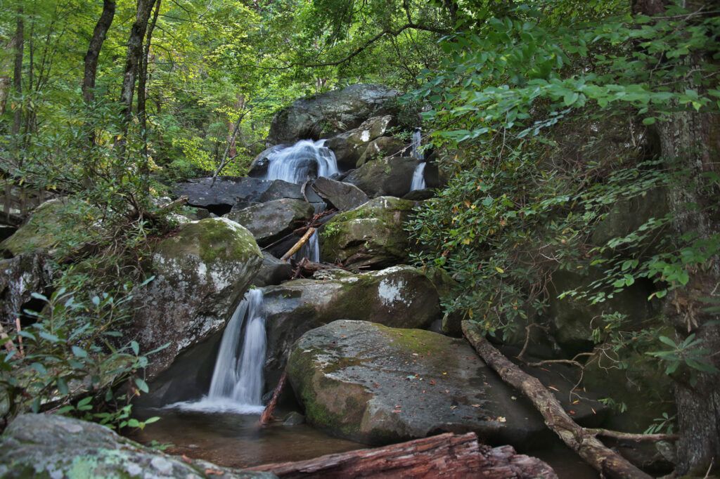
The main trail continues past several small, but really pretty cascades that run alongside the trail. Shortly after that you come to a sign where the trail splits, each trail leading to a different waterfall. If you turn right, you’ll reach Big Bear Falls. While not as impressive as High Shoals Falls, Big Bear Falls (marked with orange rectangles) is still quite impressive and worth a visit either before or after High Shoals Falls. The trail to Big Bear Falls from this point is an easy 0.4 round trip and returns to the main trail.
If you go straight/left and cross the bridge over the creek you’ll start the High Shoals Fall Trail, which is marked by blue circles. Shortly after crossing the bridge the trail starts to climb upward. There’s several picnic tables off to the right should you decide to eat a quick lunch or snack before heading to the waterfall.
The trail continues to get steeper and gets rocky. Little children or those with knee or back issues may have trouble with the trail at this point. It continues to get rockier as you go until you reach the viewing platform. This is the section of the trail that gives the trail it’s moderate/strenuous description. The park lists the trail as strenuous, but I’d consider the out and back as moderate. The trail has an elevation gain of 298 feet.
There is a long viewing platform that goes in front and along the sides of High Shoals Falls. Park officials warn visitors to stay off the rocks and not cross over the railing. Normally the loop trail would continue after this point, however the rest of the trail is closed until further notice.
This waterfall is unlike any other waterfall I’ve seen before. There’s water spilling out from cracks and over rocks everywhere. Just when you think you’ve seen it all, you climb further up and see that there is more to enjoy.
Having arrived later in the day and explored Big Bear Falls first, we had High Shoals Falls all to ourselves. I’m glad we did since it would have been crowded and hard to enjoy the waterfall with so many visitors in the observation area and then trying to turn around and return with other people on the deck. So if you notice a group or groups of people heading toward High Shoals Falls, like we did, consider exploring Big Bear Falls first and then visiting High Shoals Falls.
Once you have enjoyed High Shoals Falls you return the way you came. From there you can either turn right and cross the bridge to head to Big Bear Falls or turn left to return to the parking lot.
It was getting dark when we were returning to the parking area and it was challenging navigating the rocky areas and was dark by the time we got to the bridge crossing at the split. I’d recommend packing a flashlight if you think it could get dark while you are there. Luckily we had lights on our phones and when we got closer to the restroom it was lit with a red light.
South Mountains State Park has numerous trails for both walking, horseback riding and biking. Camping is also available.
Dogs are permitted in the park, however they must be on an attended leash, no longer than 6 feet, at all times. Pet owners who do not have their pets on a leash will receive a fine. The park has more rules for pets here.
Leave a Reply