Southeast Waterfall & Hiking Guide

Your Hiking Guide to Waterfalls and more in the Southeast US

  • Home
  • About
  • Ease of Trail
    • Roadside
    • Wheelchair Accessible
    • Easy
    • Moderate
    • Strenuous/Hard
  • Fall Location
    • Georgia
    • North Carolina
    • South Carolina
    • Kentucky
    • Tennessee
    • Virginia
  • Waterfall Trips
    • Day Trip
    • 3 to 5 Day Trip
  • Area Attractions
    • Bridges
  • Hiking
  • Blog
    • News
    • Photography
  • Terms to Know
Home

Issaqueena Falls

Posted on March 5, 2017 Written by 1 Comment

Nearby Areas: Walhalla   State: South Carolina   Ease of Trail: Easy, Moderate

Issaqueena Falls
View of Issaqueena Falls from the observation deck

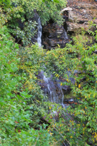
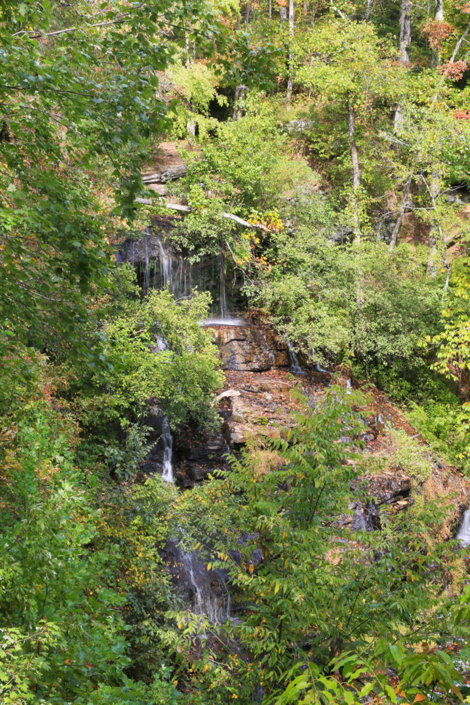
Issaqueena Falls is a 100 foot waterfall located inside Stumphouse Tunnel Park (note that there is a $5 parking fee at the park) about 7 miles west of Walhalla.  Issaqueena Falls can be viewed from a observation deck about 200 yards from the parking lot. However, it is sometimes obstructed by the trees.

From the observation deck there is a steep trail to your right that will take you to the base of the waterfall. The trail to the observation deck is easy, however the trail to the base of the waterfall is moderate.

Beginning of Issaqueena Trail
Beginning of trail to Observation Deck


Many people believe that the waterfall was named from the story of a Creek woman named Issaqueena. Legend tells that Issaqueena was captured by the Cherokee as a girl. Later she met and fell in love with a trader named Allan Francis. One day she overheard a plan to attack the frontier where Allan’s fort was. She traveled 96 miles to warn him. Issaqueena remained with Allan and married him. One day the Cherokee Chief sent warriors to capture Issaqueena. She saw them coming and ran toward this waterfall to escape capture, knowing that the Cherokee believed evil spirits lived in waterfalls. She pretended to leap to hear death, hiding on the ledge below the top of the waterfall until they left and rejoined her family.

Nearby there is a picnic area and Stumphouse Tunnel, which is 25 feet high and 17 feet wide.  The tunnel is the remains of an 1850s attempt to link the port of Charleston to the cities of the Midwest by rail. However the Civil War brought the construction to an end, extending 1,617 feet into the mountain. You can walk a ways into the tunnel, but it is really dark and you will need a flashlight to find your way.
Issaqueena Falls 2

Share:

  • Click to share on Facebook (Opens in new window) Facebook
  • Click to share on X (Opens in new window) X
  • Click to share on WhatsApp (Opens in new window) WhatsApp
  • Click to share on Pinterest (Opens in new window) Pinterest
  • More
  • Click to share on Pocket (Opens in new window) Pocket
  • Click to share on Tumblr (Opens in new window) Tumblr
  • Click to share on Reddit (Opens in new window) Reddit
  • Click to print (Opens in new window) Print

Like this:

Like Loading...

Related

Directions

Issaqueena Falls is located inside Stumphouse Tunnel Park about 7 miles west of Walhalla, SC on SC28. From Asheville area, take I-26 east. Get off at exit 54 and go south on US25 for 16 miles into South Carolina and exit at SC11. Turn left on Highway 11 and go 4.5 miles to a stop sign. Turn right to stay on 11 and drive 44 miles to SC28. Go west onto SC28 toward Walhalla. Drive through town, then another 6.9 miles and right turn into Stumphouse Tunnel Park. Drive a short distance into the park and look for the pay station on the right. The fee is $2 per vehicle. Look for a right turn into the picnic/parking area which is at the top of the waterfall.

GPS Coordinates

To the Waterfall:Lat: 34.8071, Lon: -83.1213

Nearby Areas: Walhalla

State: South Carolina

Ease of Trail: Easy, Moderate

Comments

  1. Karen says

    March 19, 2017 at 12:07 PM

    My family lives close to hear. This isn’t the most impressive waterfall, but it is quite pretty after a good rain. But if it does rain bring hiking boots because it does get slippery.

    Reply

Leave a ReplyCancel reply

Recently Added Waterfalls

  • Logan Creek Falls (also known as Falls Of Logan Creek)
    State: Virginia
    Trail Ease: Easy
  • Meadow Branch Cascades
    Meadow Branch Cascades
    State: Tennessee
    Trail Ease: Roadside
  • Whiteoak Flats Branch Falls
    Whiteoak Flats Branch Falls
    State: Tennessee
    Trail Ease: Roadside
  • Twin Falls
    Cane Creek Twin Falls
    State: Tennessee
    Trail Ease: Easy, Roadside
  • Machine Falls
    Machine Falls
    State: Tennessee
    Trail Ease: Easy, Moderate

Recently Added Trips

  • The Sinks 2
    Smoky Mountain Roadside Waterfall Day Trip
  • Little Egypt Falls
    Wartburg Area Waterfall Day Trip
  • Rutledge Falls at the base
    Tullahoma Family Friendly Waterfall Day Trip
  • Lower Greeter Falls in the Spring
    South Central Tennessee 3-5 Day Trip
  • Full length of Pine Ridge Falls
    Erwin Area Waterfall Day Trip
  • Upper Falls Graveyard Fields
    Blue Ridge Parkway to Highlands Road Trip
  • City Lake Falls
    Southeast Tennessee: Cookeville to Tellico Plains 3-5 Day Waterfall Road Trip

Fall Trails by Difficulty

  • Easy (104 trails)
  • Moderate (42 trails)
  • Wheelchair Accessible (9 trails)
  • Roadside (40 trails)
  • Strenuous (9 trails)

Waterfalls by State

  • Georgia (5 trails)
  • South Carolina (9 trails)
  • North Carolina (47 trails)
  • Tennessee (71 trails)
  • Virginia (9 trails)
  • Kentucky (4 trails)

Copyright Info
Privacy Policy

Supporting the Site
Disclaimer & Info
About the Authors
Wesite developed by Waltdesign & Development.
%d