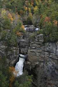
 Linville Falls is located on the Blue Ridge Parkway at mile post 316.4. The total height of the falls is 150 feet with four drops. Linville Falls starts with a twin set of upper falls, moving into a small gorge, and ending in a high-volume, 45-foot drop. Linville Falls, formed by Linville River, marks the beginning of Linville Gorge. Linville River continues on after the falls ending near Lake James.
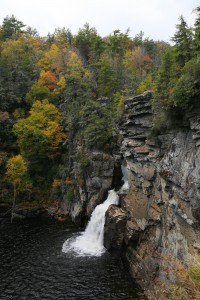
There are four different overlooks that you can hike to different views of Linville Falls. Unlike some falls where the different overviews provide a similar view, you will find that all the views are very different and are extremely beautiful. I recommend them all.
You will also notice that this waterfall is list as having, and Easy, Moderate, and Strenuous hiking trail. That is because there are different trails that you can take. When I was young, we’d sometimes go here, and my mother could only do the easy trail. However, I’d go with my father on the moderate trails. Since then, I’ve also taken the strenuous trails as they lead you to the base of the waterfall.
The Easy Trail
The 0.5-mile Upper Falls trail leads to the top of Linville Falls, where you can see the two small upper falls. This is an easy trail, which is wide and accessible to everyone.
The Moderate Trails
Erwin’s View Trail (1.6 mile round trip) goes to two overlooks, Erwin’s View, which is a 0.8 mile hike, and Chimney View, which is a 0.7 miles hike. These are a little steeper than the Upper Falls trail, and are considered to be a moderate trail. The trail is generally well maintained and free of most obstacles although it can be a bit steep in some sections, which is why it is listed as a moderate trail.
Harder Trails to Traverse

The 0.5-mile Plunge Basin Trail leads to Plunge Basin Overlook, gives you a view of Linville Falls from the other side of the river. The Gorge Trail, which is a 0.7 mile hike, branches off from the Plunge Basin trail, taking you to an area near the base of the falls. These are moderate and strenuous trails respectively. Our 9 year old son was able to handle both without issue, except for some assistance climbing over a fallen tree.
When to Visit
Linville Falls is very popular, so during summer and fall it is best to visit on the weekdays to avoid the crowds. The Blue Ridge Parkway has a large parking log, but it can still overflow during the busy times of the season. We have noticed that fall, with the changing of the leaves is the busiest time, and for good reason. If you come from the Blue Ridge Parkway, there is a small range station and gift store. We like to take our family photo there, with the bridge and the changing leaves in the background.
Linville Falls is one of my wife and I’s favorite waterfall. It’s not far from us so we visit it frequently. I would highly recommend it.