Southeast Waterfall & Hiking Guide

Your Hiking Guide to Waterfalls and more in the Southeast US

  • Home
  • About
  • Ease of Trail
    • Roadside
    • Wheelchair Accessible
    • Easy
    • Moderate
    • Strenuous/Hard
  • Fall Location
    • Georgia
    • North Carolina
    • South Carolina
    • Kentucky
    • Tennessee
    • Virginia
  • Waterfall Trips
    • Day Trip
    • 3 to 5 Day Trip
  • Area Attractions
    • Bridges
  • Hiking
  • Blog
    • News
    • Photography
  • Terms to Know
Home

Lower Higgins Creek Falls

Posted on April 10, 2024 Written by Leave a Comment

Nearby Areas: Erwin, Rocky Fork State Park   State: Tennessee   Ease of Trail: Moderate

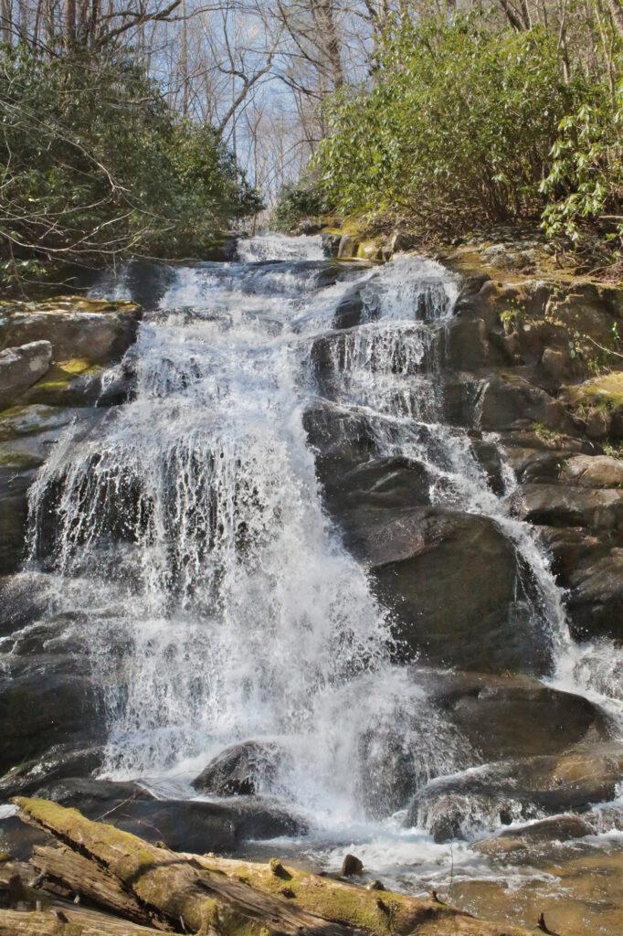
Lower Higgins Creek Falls is a beautiful waterfall located in the Cherokee National Forest, but it can be challenging to get to. Although in my opinion it is totally worth the effort. The total height for Lower Higgins Creek Falls is 100 feet and the main section, which is what most people visit is 50-60 feet.

While the trail is fairly short, it is very steep. The good news is that it is harder going to the waterfall and much easier returning to the parking lot. The trail starts after the blue gate, which the paint was very faded when we visited. As the trail continues on it gets steeper and rockier. I would recommend hiking sticks or adjustable hiking poles if you have trouble hiking on steep or rocky trails. At the time of our visit there were also some trees that had fallen onto the trail, but they weren’t difficult to climb over or go around.

We went in Spring after a good rain so the trail was muddy, but not too slippery. At about 0.25 miles you’ll come to a small creek crossing. We were able to walk across on rocks and keep our shoes dry, however be sure to take it slowly as the rocks were a little loose and slippery in some areas. After a short distance you’ll come to another creek crossing. This is where we encountered a snake on the trail. We left him alone and he continued on his way. A few minutes later we continued on our way.

The trail follows alongside the creek. It is quite pretty. The worst part of the hike is after the creek crossings. This is where the trail gets steeper and rockier until you reach the waterfall at around 0.6-0.8 miles.

View of Lower Higgins Creek Falls from the trail

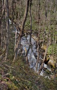
You can see the waterfall from the trail, but it is obstructed by a lot of trees, so if you want a good view you’ll need to climb down to the base of the waterfall along a side “trail”. Here’s where those hiking poles come in handy. The view from the base of the waterfalls is worth the effort.

It was at this point that we turned around and returned to the parking lot. Everything was much easier going back along the trail to return to our car.

There are several waterfalls in the area if you want to make a day trip of it. While in the area, I would recommend visiting Middle Spivey Falls, Lower Spivey Falls and Big Creek Falls. Lower Spivey Falls is on private property, but the owners allow viewing from behind a fence. Big Creek Falls is just a short distance away across the North Carolina state line.

View of Lower Higgins Creek Falls from the base

Share:

  • Click to share on Facebook (Opens in new window) Facebook
  • Click to share on X (Opens in new window) X
  • Click to share on WhatsApp (Opens in new window) WhatsApp
  • Click to share on Pinterest (Opens in new window) Pinterest
  • More
  • Click to share on Pocket (Opens in new window) Pocket
  • Click to share on Tumblr (Opens in new window) Tumblr
  • Click to share on Reddit (Opens in new window) Reddit
  • Click to print (Opens in new window) Print

Like this:

Like Loading...

Related

Directions

From Tennessee: get on I-26 east and get off at exit 43. After exiting, turn left and continue to the stop sign to US19W. Turn right onto US19W. Drive 0.75 miles and then turn right onto Lower Higgins Creek Rd. Cross the bridge and continue down the road until it dead ends into the parking lot. If you have a low clearance vehicle you will want to park in the spaces just after the 'Parking .2 miles Ahead' sign and walk the rest of the road to the trailhead.

Nearby Areas: Erwin, Rocky Fork State Park

State: Tennessee

Ease of Trail: Moderate

Leave a ReplyCancel reply

Recently Added Waterfalls

  • Meadow Branch Cascades
    Meadow Branch Cascades
    State: Tennessee
    Trail Ease: Roadside
  • Whiteoak Flats Branch Falls
    Whiteoak Flats Branch Falls
    State: Tennessee
    Trail Ease: Roadside
  • Twin Falls
    Cane Creek Twin Falls
    State: Tennessee
    Trail Ease: Easy, Roadside
  • Machine Falls
    Machine Falls
    State: Tennessee
    Trail Ease: Easy, Moderate
  • Rutledge Falls at the base
    Rutledge Falls
    State: Tennessee
    Trail Ease: Easy

Recently Added Trips

  • The Sinks 2
    Smoky Mountain Roadside Waterfall Day Trip
  • Little Egypt Falls
    Wartburg Area Waterfall Day Trip
  • Rutledge Falls at the base
    Tullahoma Family Friendly Waterfall Day Trip
  • Lower Greeter Falls in the Spring
    South Central Tennessee 3-5 Day Trip
  • Full length of Pine Ridge Falls
    Erwin Area Waterfall Day Trip
  • Upper Falls Graveyard Fields
    Blue Ridge Parkway to Highlands Road Trip
  • City Lake Falls
    Southeast Tennessee: Cookeville to Tellico Plains 3-5 Day Waterfall Road Trip

Fall Trails by Difficulty

  • Easy (103 trails)
  • Moderate (42 trails)
  • Wheelchair Accessible (9 trails)
  • Roadside (40 trails)
  • Strenuous (9 trails)

Waterfalls by State

  • Georgia (5 trails)
  • South Carolina (9 trails)
  • North Carolina (47 trails)
  • Tennessee (71 trails)
  • Virginia (8 trails)
  • Kentucky (4 trails)

Copyright Info
Privacy Policy

Supporting the Site
Disclaimer & Info
About the Authors
Wesite developed by Waltdesign & Development.
%d