Southeast Waterfall & Hiking Guide

Your Hiking Guide to Waterfalls and more in the Southeast US

  • Home
  • About
  • Ease of Trail
    • Roadside
    • Wheelchair Accessible
    • Easy
    • Moderate
    • Strenuous/Hard
  • Fall Location
    • Georgia
    • North Carolina
    • South Carolina
    • Kentucky
    • Tennessee
    • Virginia
  • Waterfall Trips
    • Day Trip
    • 3 to 5 Day Trip
  • Area Attractions
    • Bridges
  • Hiking
  • Blog
    • News
    • Photography
  • Terms to Know
Home

Middle Spivey Falls

Posted on August 20, 2016 Written by Leave a Comment

Nearby Areas: Erwin   State: Tennessee   Ease of Trail: Moderate

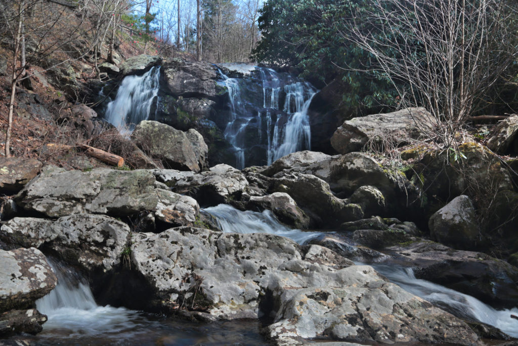
Middle Spivey Falls isn’t the easiest waterfall to find or photograph, but it is worth it. It is not crowded like many other waterfalls, in fact we were the only ones there so we had plenty of time to ourselves to absorb the beauty and tranquility. Middle Spivey Falls is best photographed early in the morning or on an overcast day.

Middle Spivey Falls can be reached by a path the includes wooden and stone steps most of the way. You can also reach the waterfall via a turnoff with enough room to park one car. It’s a pretty steep descent down to the base of the waterfall, but it can be done moving carefully.

There are several waterfalls in the area if you want to make a day trip of it. While in the area, I would recommend visiting Lower Spivey Falls and Big Creek Falls like we did. Lower Spivey Falls is on private property, but the owners allow viewing from behind a fence. Big Creek Falls is just a short distance away across the North Carolina state line.

Upper Spivey Falls

Share:

  • Click to share on Facebook (Opens in new window) Facebook
  • Click to share on X (Opens in new window) X
  • Click to share on WhatsApp (Opens in new window) WhatsApp
  • Click to share on Pinterest (Opens in new window) Pinterest
  • More
  • Click to share on Pocket (Opens in new window) Pocket
  • Click to share on Tumblr (Opens in new window) Tumblr
  • Click to share on Reddit (Opens in new window) Reddit
  • Click to print (Opens in new window) Print

Like this:

Like Loading...

Related

Directions

Take Interstate 26 and get off at exit 12/Temple Hill Road. Go south on U.S. 19W for 1.1 miles. Turn left, staying on 19W and go 4 miles to an undesignated turnoff on the right side of the road. Just past the turnoff is a driveway and a small sign noting the trailhead to the falls.

Nearby Areas: Erwin

State: Tennessee

Ease of Trail: Moderate

Leave a ReplyCancel reply

Recently Added Waterfalls

  • Logan Creek Falls (also known as Falls Of Logan Creek)
    State: Virginia
    Trail Ease: Easy
  • Meadow Branch Cascades
    Meadow Branch Cascades
    State: Tennessee
    Trail Ease: Roadside
  • Whiteoak Flats Branch Falls
    Whiteoak Flats Branch Falls
    State: Tennessee
    Trail Ease: Roadside
  • Twin Falls
    Cane Creek Twin Falls
    State: Tennessee
    Trail Ease: Easy, Roadside
  • Machine Falls
    Machine Falls
    State: Tennessee
    Trail Ease: Easy, Moderate

Recently Added Trips

  • The Sinks 2
    Smoky Mountain Roadside Waterfall Day Trip
  • Little Egypt Falls
    Wartburg Area Waterfall Day Trip
  • Rutledge Falls at the base
    Tullahoma Family Friendly Waterfall Day Trip
  • Lower Greeter Falls in the Spring
    South Central Tennessee 3-5 Day Trip
  • Full length of Pine Ridge Falls
    Erwin Area Waterfall Day Trip
  • Upper Falls Graveyard Fields
    Blue Ridge Parkway to Highlands Road Trip
  • City Lake Falls
    Southeast Tennessee: Cookeville to Tellico Plains 3-5 Day Waterfall Road Trip

Fall Trails by Difficulty

  • Easy (104 trails)
  • Moderate (42 trails)
  • Wheelchair Accessible (9 trails)
  • Roadside (40 trails)
  • Strenuous (9 trails)

Waterfalls by State

  • Georgia (5 trails)
  • South Carolina (9 trails)
  • North Carolina (47 trails)
  • Tennessee (71 trails)
  • Virginia (9 trails)
  • Kentucky (4 trails)

Copyright Info
Privacy Policy

Supporting the Site
Disclaimer & Info
About the Authors
Wesite developed by Waltdesign & Development.
%d