Southeast Waterfall & Hiking Guide

Your Hiking Guide to Waterfalls and more in the Southeast US

  • Home
  • About
  • Ease of Trail
    • Roadside
    • Wheelchair Accessible
    • Easy
    • Moderate
    • Strenuous/Hard
  • Fall Location
    • Georgia
    • North Carolina
    • South Carolina
    • Kentucky
    • Tennessee
    • Virginia
  • Waterfall Trips
    • Day Trip
    • 3 to 5 Day Trip
  • Area Attractions
    • Bridges
  • Hiking
  • Blog
    • News
    • Photography
  • Terms to Know
Home

Mock’s Mill Falls

Posted on October 18, 2020 Written by Leave a Comment

Nearby Areas: Abingdon, Alvarado Road Falls, Backbone Falls, Backbone Rock, Damascus, Virginia Creeper Trail   State: Virginia   Ease of Trail: Roadside

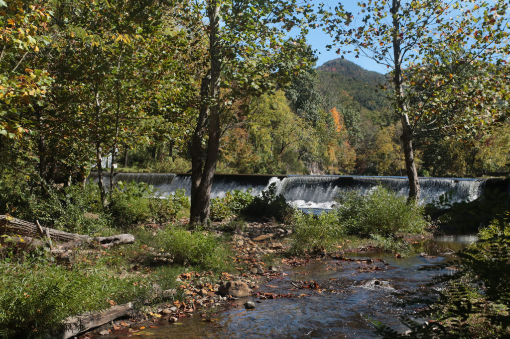
Mock’s Mill Falls is a man-made waterfall less than 15 feet in height by very wide. What this waterfall lacks in height, it makes up for in its beautiful backdrop and ease of viewing.

Mock’s Mill Falls was named after Henry A. Mock who created the waterfall in the early 1800s to power a grist mill for grinding grain into flour. The town it is located in was originally called Mock’s Mill, which has since been changed to Damascus.

Mock’s Mill remained in operation well into the 20th century. Once the mill closed the waterwheel was removed and the building has been renovated into the Damascus Old Mill Inn hotel and restaurant. You can park in a parking area behind the hotel and walk toward the hotel from the parking area. You’ll see the waterfall just below the hotel directly behind it.

Just 8 minutes away is the beautiful Backbone Falls and Backbone Rock just across the Tennessee border. In 1901, a tunnel was drilled through the rock to allow railroad access between Shady Valley and Damascus creating Backbone Rock, “The Shortest Tunnel in the World”. There’s lots of hiking opportunities in this area as well as a lake to picnic at. The Virginia Creeper Trail is nearby as well as a train exhibit in the parking area for the Creeper Trail in Damascus. And don’t forget to visit Alvarado Road Falls while you are there.

We also drove along the nearby US-58 to check out the sights as we visited in fall and the leaves were at peak, so we were treated with a beautiful array of color.

Share:

  • Click to share on Facebook (Opens in new window) Facebook
  • Click to share on X (Opens in new window) X
  • Click to share on WhatsApp (Opens in new window) WhatsApp
  • Click to share on Pinterest (Opens in new window) Pinterest
  • More
  • Click to share on Pocket (Opens in new window) Pocket
  • Click to share on Tumblr (Opens in new window) Tumblr
  • Click to share on Reddit (Opens in new window) Reddit
  • Click to print (Opens in new window) Print

Like this:

Like Loading...

Related

Directions

From Abingdon: Drive along US-58 East until you reach Damascus. After you cross the bridge, take the first road on your left. Go about a block and you'll dead end into the Damascus Old Mill Inn hotel and restaurant. Waterfall parking is available behind the hotel/restaurant.

GPS Coordinates

To the Waterfall:36° 38.200' N, 81° 47.400' W

Nearby Areas: Abingdon, Alvarado Road Falls, Backbone Falls, Backbone Rock, Damascus, Virginia Creeper Trail

State: Virginia

Ease of Trail: Roadside

Leave a ReplyCancel reply

Recently Added Waterfalls

  • Meadow Branch Cascades
    Meadow Branch Cascades
    State: Tennessee
    Trail Ease: Roadside
  • Whiteoak Flats Branch Falls
    Whiteoak Flats Branch Falls
    State: Tennessee
    Trail Ease: Roadside
  • Twin Falls
    Cane Creek Twin Falls
    State: Tennessee
    Trail Ease: Easy, Roadside
  • Machine Falls
    Machine Falls
    State: Tennessee
    Trail Ease: Easy, Moderate
  • Rutledge Falls at the base
    Rutledge Falls
    State: Tennessee
    Trail Ease: Easy

Recently Added Trips

  • The Sinks 2
    Smoky Mountain Roadside Waterfall Day Trip
  • Little Egypt Falls
    Wartburg Area Waterfall Day Trip
  • Rutledge Falls at the base
    Tullahoma Family Friendly Waterfall Day Trip
  • Lower Greeter Falls in the Spring
    South Central Tennessee 3-5 Day Trip
  • Full length of Pine Ridge Falls
    Erwin Area Waterfall Day Trip
  • Upper Falls Graveyard Fields
    Blue Ridge Parkway to Highlands Road Trip
  • City Lake Falls
    Southeast Tennessee: Cookeville to Tellico Plains 3-5 Day Waterfall Road Trip

Fall Trails by Difficulty

  • Easy (103 trails)
  • Moderate (42 trails)
  • Wheelchair Accessible (9 trails)
  • Roadside (40 trails)
  • Strenuous (9 trails)

Waterfalls by State

  • Georgia (5 trails)
  • South Carolina (9 trails)
  • North Carolina (47 trails)
  • Tennessee (71 trails)
  • Virginia (8 trails)
  • Kentucky (4 trails)

Copyright Info
Privacy Policy

Supporting the Site
Disclaimer & Info
About the Authors
Wesite developed by Waltdesign & Development.
%d