Pleasant Ridge Falls, located inside Pleasant Ridge County Park, is an easy 0.2 mile hike down the nature trail. Pleasant Ridge County Park is located 5 miles from Jones Gap and Caesar’s Head State Parks.
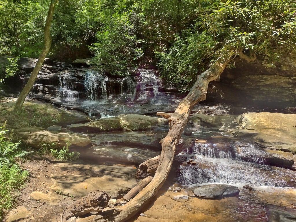
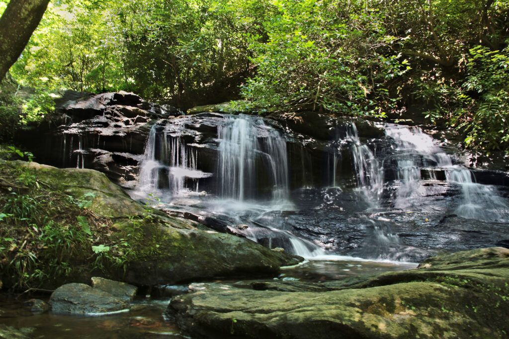
Pleasant Ridge Falls is a two-tiered waterfall. The first tier is 8 feet tall and then it continues for another 25 feet before the second tier which is another 15 feet.
While researching waterfalls near Greenville that we hadn’t previously visited, I came across Pleasant Ridge Falls. This waterfall, while close to many of the larger waterfalls in the area, doesn’t have nearly the crowds, which is perfect for a quiet waterfall hike.
Many people complain that the trail to the waterfall is difficult to find, however we found it without issue. When you enter the entrance to Pleasant Ridge County Park, park right by Shelter #1. Cross a small wooden “bridge” that you will find to the right of the shelter if you are facing it, and head to the left. You’ll see a trail marker sign for the Leroy Smith Natural Trail with an arrow pointing to the Falls Loop Trail. Follow the trail and at 0.1 miles the waterfall will be on your right, just below the trail.
The trail was named after Leroy Smith, the first African-American superintendent of a South Carolina State Park in 1951. Mr. Smith served as superintendent until his death in 1979.
We had the trail all to ourselves, which was surprising for a weekend during the summer. There were two places to sit at by the top tier of the waterfall where you can sit and relax, which we took advantage of. The loop trail continued on for another 0.7 miles, which passes by the site of an old moonshine still and the remains of a grist mill. However, we elected to return to the car the way we came, bringing our total distance to 0.2 miles round trip.
The day we visited the area hadn’t had much rain in a while, so the waterfall had low flow.
The park also has restroom facilities and a picnic shelter (one of three in the park) right off the parking lot just before the entrance to the Falls Trail.
Dogs are welcome at Pleasant Ridge County Park, but must be on a leash.
Other Things Available at Pleasant Ridge Park
Pleasant Ridge Park has 8 miles of shared used hiking and mountain biking trails, both easy and moderate trails. These range in distance from .03 miles to 6 miles. If you like mountain biking, there is the 5.2 mile Jorge F. Arango (JFA) mountain bike trail is within the park.
Pleasant Ridge County Park also has a 4 acre lake where fishing is permitted, however ages 16 and older must have a fishing license. There are limitations on how many fish you can take home, which is listed on the Pleasant Ridge Park webpage. Boats are not permitted at Pleasant Ridge County Park.
There is a small playground with two swings and a metal merry-go-round.
Nearby Waterfalls
Waterfalls in Greenville include: Falls Park on the Reedy River and Rock Quarry Falls. Both of these waterfalls are easy hikes.
Waterfalls in Cleveland include: Jones Gap Falls (located in Jones Gap State Park), Raven Cliff Falls (a four-mile round trip to a scenic overlook, located in Caesar’s Head State Park) and Wildcat Branch Falls. We have not visited Jones Gap Falls or Raven Cliff Falls as the water flow was low so we are saving them for another trip. Wildcat Branch Falls is comprised of three separate waterfalls and is also known as Wildcat Wayside. The first sections of Wildcat Branch Falls are easy and the third is moderate.
Historic Bridges Nearby
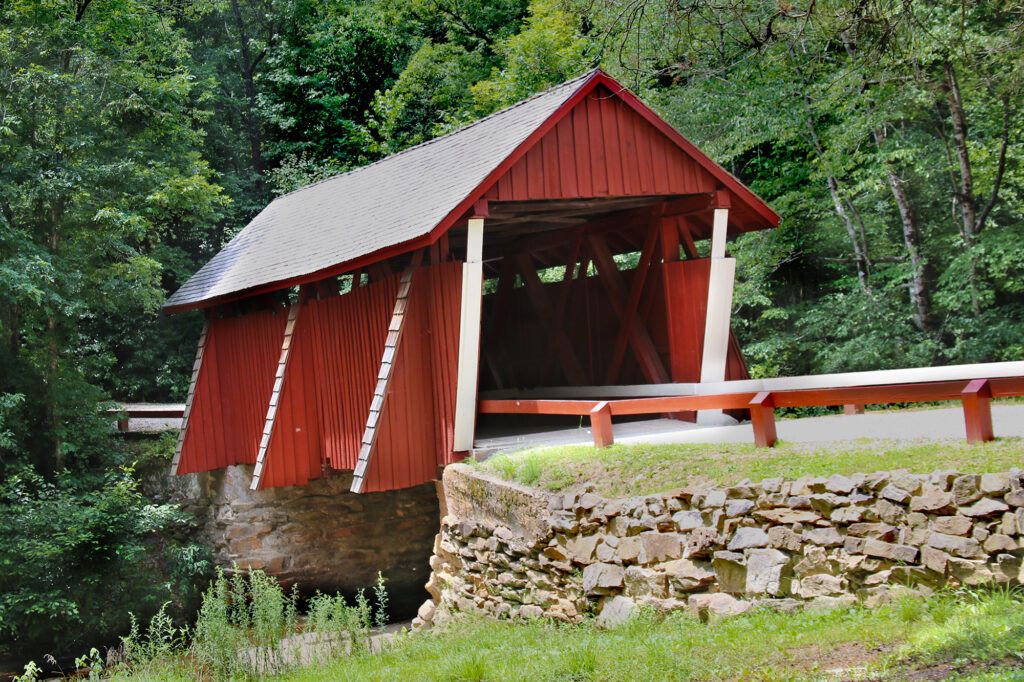
Campbell’s Covered Bridge – Built in 1909, Campbell’s Covered Bridge is the only remaining covered bridge in the State of South Carolina. The 38 foot long, 12 foot wide bridge that spans Beaverdam Creek was built by Charles Irwin Willis. The bridge is named after Alexander Lafayette Campbell, who operated the grist mill just downstream of the bridge.
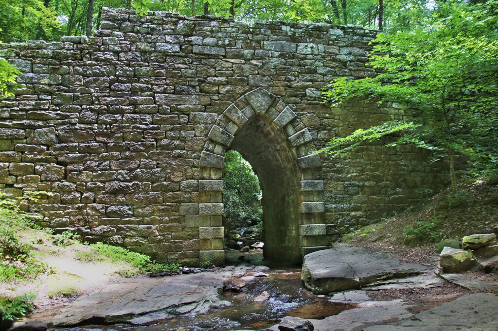
Poinsett Bridge – The oldest bridge in South Carolina, completed in 1820, part of the original road connecting Greenville to Asheville. The stone bridge, named after Joel Roberts Poinsett, includes a 14-foot Gothic arch and spans 130 feet over Little Gap Creek.
Leave a Reply