Southeast Waterfall & Hiking Guide

Your Hiking Guide to Waterfalls and more in the Southeast US

  • Home
  • About
  • Ease of Trail
    • Roadside
    • Wheelchair Accessible
    • Easy
    • Moderate
    • Strenuous/Hard
  • Fall Location
    • Georgia
    • North Carolina
    • South Carolina
    • Kentucky
    • Tennessee
    • Virginia
  • Waterfall Trips
    • Day Trip
    • 3 to 5 Day Trip
  • Area Attractions
    • Bridges
  • Hiking
  • Blog
    • News
    • Photography
  • Terms to Know
Home

Rhodendron Trail Falls

Posted on December 28, 2023 Written by 2 Comments

Nearby Areas: Gatlinburg, Great Smoky Mountains   State: Tennessee   Ease of Trail: Moderate

The waterfalls on Rhodendron Trail are not the easiest to find. If you want to see them, pay careful attention to the directions below.  It is a 1.6 miles round trip, moderate hike to see the waterfalls.

Parts of the trail are very narrow, so this trail not be the best to take with children. Also some of the paths leading down to the waterfalls are a little bit steep.

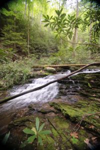
Follow the main trail until you dead-end into the stream and there is no other way to keep moving forward. Cross the stream and follow the instructions below. Please note that there are also several smaller unnamed waterfalls, while very scenic, are not listed below.

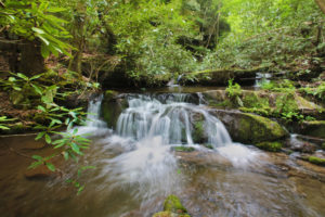
  • Oldhamii Falls – 3-6  ft., 0.2 miles, Head up the stream where the easy path becomes more difficult after 0.2 miles due to a rock hop. This is just beyond the stream crossing.
  • Rhodora Falls – 10-15 ft, Proceed about 100 yards beyond Oldhamii Falls to a very short spur trail to your left that quickly leads to the base of this fall. (0.3 from beginning of trail)
  • Pinxter Falls – After 0.1 mile beyond Rhodora Falls  the main trail will begin to ascend. You will find another short spur to the left, this one taking you to the base of this fall.
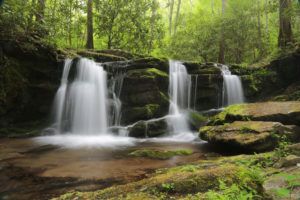
  • Mountain Laurel Falls – 7-12 ft, Go back to the main trail from Pinxter Falls, and continue heading upstream. This waterfall is just a short distance away. (0.4 from beginning of trail)
  • Glenn Dale Falls – 10-15 ft, Just beyond Mountain Laurel Falls you will come to this fall. (0.6 from beginning of trail)
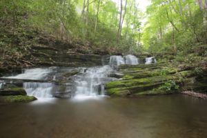
  • Azalea Falls – 10-15 ft, After Glenn Dale Falls, the trail splits. Take the lower, streamside branch to your left. Soon thereafter you will reach this fall. (0.7 from beginning of trail.)
  • Kurume Falls – 10-15 ft, Continue on the lower, streamside branch past Azalea Falls to see Kurume Falls. (0.7 from beginning of trail)
  • Alpenrose Falls – 15-25 ft, Continue walking past Kurume Falls to this uppermost descent to the final waterfall. From here it is 0.8 miles back to the beginning of trailhead. Simply turn around and go back the way you came.

We were unable to photograph all of the waterfalls listed above as we were caught in an unexpected rainstorm. We returned in August 2024 and were unable to make it past Pinxter Falls due to over a half dozen downed trees that had fallen across the trail.

Oldhamii Falls
Oldhamii Falls
Rhodora Falls
Rhodora Falls


Unnamed Fall
Unnamed waterfall between Rhodora and Pinxter Falls
Pinxter Falls
Pinxter Falls

Share:

  • Click to share on Facebook (Opens in new window) Facebook
  • Click to share on X (Opens in new window) X
  • Click to share on WhatsApp (Opens in new window) WhatsApp
  • Click to share on Pinterest (Opens in new window) Pinterest
  • More
  • Click to share on Pocket (Opens in new window) Pocket
  • Click to share on Tumblr (Opens in new window) Tumblr
  • Click to share on Reddit (Opens in new window) Reddit
  • Click to print (Opens in new window) Print

Like this:

Like Loading...

Related

Directions

From the entrance to the Great Smoky Mountains Greenbrier Station, which is located at the junction of U.S. 321 and Greenbrier Road, turn into the Smoky Mountains National Park. The distance to the parking area is 1.7 miles from the entrance to the park. There are lots of turnoffs, so check your mileage. You will pss the ranger station and keep going to a stop sign. After the stop sign, you will cross a small bridge and your parking area will be immediately on the right. The unsigned trailhead begins here.

Nearby Areas: Gatlinburg, Great Smoky Mountains

State: Tennessee

Ease of Trail: Moderate

Comments

  1. Suzi says

    February 25, 2017 at 6:15 AM

    Wow! Eight waterfalls on one trail! I will have to add this to my list of waterfalls to visit when I go to Gatlinburg this summer. They may not be big, but they sure look pretty from the photos you have.

    Reply
  2. Owen says

    May 23, 2019 at 6:08 AM

    My wife loves Gatlinburg and we try to vacation there once a year. I had never heard of these waterfalls before. I’m looking forward to checking them out on our next trip. It’s always nice to add something new!

    Reply

Leave a ReplyCancel reply

Recently Added Waterfalls

  • Logan Creek Falls (also known as Falls Of Logan Creek)
    State: Virginia
    Trail Ease: Easy
  • Meadow Branch Cascades
    Meadow Branch Cascades
    State: Tennessee
    Trail Ease: Roadside
  • Whiteoak Flats Branch Falls
    Whiteoak Flats Branch Falls
    State: Tennessee
    Trail Ease: Roadside
  • Twin Falls
    Cane Creek Twin Falls
    State: Tennessee
    Trail Ease: Easy, Roadside
  • Machine Falls
    Machine Falls
    State: Tennessee
    Trail Ease: Easy, Moderate

Recently Added Trips

  • The Sinks 2
    Smoky Mountain Roadside Waterfall Day Trip
  • Little Egypt Falls
    Wartburg Area Waterfall Day Trip
  • Rutledge Falls at the base
    Tullahoma Family Friendly Waterfall Day Trip
  • Lower Greeter Falls in the Spring
    South Central Tennessee 3-5 Day Trip
  • Full length of Pine Ridge Falls
    Erwin Area Waterfall Day Trip
  • Upper Falls Graveyard Fields
    Blue Ridge Parkway to Highlands Road Trip
  • City Lake Falls
    Southeast Tennessee: Cookeville to Tellico Plains 3-5 Day Waterfall Road Trip

Fall Trails by Difficulty

  • Easy (104 trails)
  • Moderate (42 trails)
  • Wheelchair Accessible (9 trails)
  • Roadside (40 trails)
  • Strenuous (9 trails)

Waterfalls by State

  • Georgia (5 trails)
  • South Carolina (9 trails)
  • North Carolina (47 trails)
  • Tennessee (71 trails)
  • Virginia (9 trails)
  • Kentucky (4 trails)

Copyright Info
Privacy Policy

Supporting the Site
Disclaimer & Info
About the Authors
Wesite developed by Waltdesign & Development.
%d