Southeast Waterfall & Hiking Guide

Your Hiking Guide to Waterfalls and more in the Southeast US

  • Home
  • About
  • Ease of Trail
    • Roadside
    • Wheelchair Accessible
    • Easy
    • Moderate
    • Strenuous/Hard
  • Fall Location
    • Georgia
    • North Carolina
    • South Carolina
    • Kentucky
    • Tennessee
    • Virginia
  • Waterfall Trips
    • Day Trip
    • 3 to 5 Day Trip
  • Area Attractions
    • Bridges
  • Hiking
  • Blog
    • News
    • Photography
  • Terms to Know
Home

Roaring Fork Creek Falls

Posted on November 16, 2022 Written by Leave a Comment

Nearby Areas: Blue Ridge Parkway, Burnsville, Crabtree Falls, Pisgah National Forest, Setrock Creek Falls   State: North Carolina   Ease of Trail: Easy

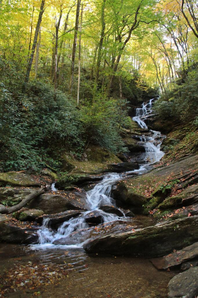
Roaring Fork Creek Falls, located in the Pisgah National Forest in Burnsville, NC, is a long 50 foot cascade in a very pretty setting. Roaring Fork Falls is almost as long as it is high, with numerous cascades pouring into a small, clear pool at the base. Roaring Fork Creek feeds into the nearby Toe River and the falls is surrounded by rhododendron, which are very pretty when blooming. It’s easy to find and an easy 1 mile round trip hike.

The hike to Roaring Fork Creek Falls starts on the opposite side of the road from the parking area. You will see a sign pointing you toward the falls. Go around the gate onto a mostly flat forest service road, which winds gradually uphill. You will pass several bunkers formerly used to store explosives along the side of the trail. Just before the road crosses the creek, turn right and cross a small wooden bridge, onto the Roaring Fork Falls trail. This forest path is easy, slightly uphill, and ends at Roaring Fork Creek Falls about 300 feet from the bridge.

Waterfalls nearby include Setrock Creek Falls and Crabtree Falls. Other sights nearby are the Blue Ridge Parkway, Pisgah National Forest, Mount Mitchell State Park and the Mount Mitchell Golf Club Resort.

Roaring Fork Creek Falls

Share:

  • Click to share on Facebook (Opens in new window) Facebook
  • Click to share on X (Opens in new window) X
  • Click to share on WhatsApp (Opens in new window) WhatsApp
  • Click to share on Pinterest (Opens in new window) Pinterest
  • More
  • Click to share on Pocket (Opens in new window) Pocket
  • Click to share on Tumblr (Opens in new window) Tumblr
  • Click to share on Reddit (Opens in new window) Reddit
  • Click to print (Opens in new window) Print

Like this:

Like Loading...

Related

Directions

From the intersection of the Blue Ridge Parkway and Highway 80, go about 2.2 miles west and turn left onto South Toe River Rd. You'll see a sign for Black Mountain Campground. Cross the bridge and immediately turn left onto the road leading to the Busick Work Center. The parking area is on the left in about 0.2 mile, right in front of the gate to the Work Center.

GPS Coordinates

To the Waterfall:35.75996, -82.191643

Nearby Areas: Blue Ridge Parkway, Burnsville, Crabtree Falls, Pisgah National Forest, Setrock Creek Falls

State: North Carolina

Ease of Trail: Easy

Leave a ReplyCancel reply

Recently Added Waterfalls

  • Meadow Branch Cascades
    Meadow Branch Cascades
    State: Tennessee
    Trail Ease: Roadside
  • Whiteoak Flats Branch Falls
    Whiteoak Flats Branch Falls
    State: Tennessee
    Trail Ease: Roadside
  • Twin Falls
    Cane Creek Twin Falls
    State: Tennessee
    Trail Ease: Easy, Roadside
  • Machine Falls
    Machine Falls
    State: Tennessee
    Trail Ease: Easy, Moderate
  • Rutledge Falls at the base
    Rutledge Falls
    State: Tennessee
    Trail Ease: Easy

Recently Added Trips

  • The Sinks 2
    Smoky Mountain Roadside Waterfall Day Trip
  • Little Egypt Falls
    Wartburg Area Waterfall Day Trip
  • Rutledge Falls at the base
    Tullahoma Family Friendly Waterfall Day Trip
  • Lower Greeter Falls in the Spring
    South Central Tennessee 3-5 Day Trip
  • Full length of Pine Ridge Falls
    Erwin Area Waterfall Day Trip
  • Upper Falls Graveyard Fields
    Blue Ridge Parkway to Highlands Road Trip
  • City Lake Falls
    Southeast Tennessee: Cookeville to Tellico Plains 3-5 Day Waterfall Road Trip

Fall Trails by Difficulty

  • Easy (103 trails)
  • Moderate (42 trails)
  • Wheelchair Accessible (9 trails)
  • Roadside (40 trails)
  • Strenuous (9 trails)

Waterfalls by State

  • Georgia (5 trails)
  • South Carolina (9 trails)
  • North Carolina (47 trails)
  • Tennessee (71 trails)
  • Virginia (8 trails)
  • Kentucky (4 trails)

Copyright Info
Privacy Policy

Supporting the Site
Disclaimer & Info
About the Authors
Wesite developed by Waltdesign & Development.
%d