Southeast Waterfall & Hiking Guide

Your Hiking Guide to Waterfalls and more in the Southeast US

  • Home
  • About
  • Ease of Trail
    • Roadside
    • Wheelchair Accessible
    • Easy
    • Moderate
    • Strenuous/Hard
  • Fall Location
    • Georgia
    • North Carolina
    • South Carolina
    • Kentucky
    • Tennessee
    • Virginia
  • Waterfall Trips
    • Day Trip
    • 3 to 5 Day Trip
  • Area Attractions
    • Bridges
  • Hiking
  • Blog
    • News
    • Photography
  • Terms to Know
Home

Setrock Creek Falls

Posted on November 20, 2022 Written by Leave a Comment

Nearby Areas: Blue Ridge Parkway, Burnsville, Crabtree Falls, Pisgah National Forest, Roaring Fork Creek Falls   State: North Carolina   Ease of Trail: Easy

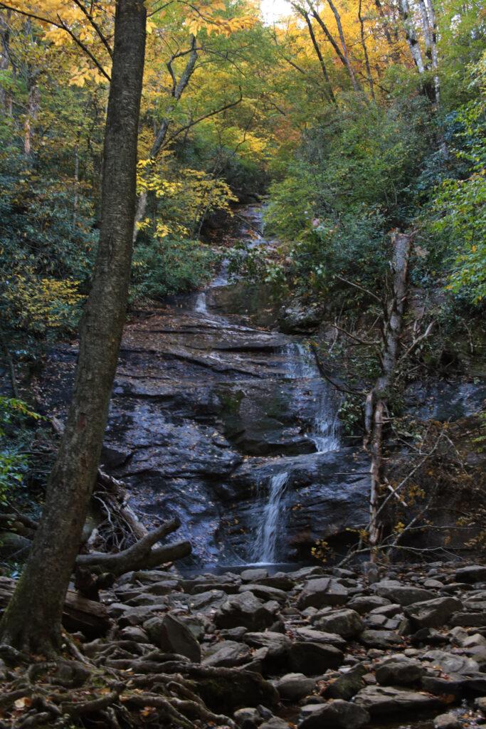
Setrock Creek Falls is a 75 foot waterfall that is off the beaten path. It is located in the Pisgah National Forest in Burnsville, North Carolina at the base of Mount Mitchell. The waterfall is located inside the Black Mountain Campground, so if you’re not camping there you will need to park in the parking lot across from the bridge from the campground entrance.

The trail can be a bit challenging to find. From the parking lot across from the campground, you’ll cross the bridge and take the first road to the left (just across from the campground office). Stay on the road.

You’ll pass a multi-trail entrance on your left. Do not take this trail. After a short walk up the road you will see a trail post marker for the Mt. Mitchell trail on your right. Continue on the road until you get to the trail entrance with a marker for Setrock Falls.

The trail is an easy 1 mile out and back round trip. The trail is clearly defined and leads straight to the waterfall, however there are a lot of roots covering the trail. After you have hiked to Setrock Creek Falls, return to your car the way you came.

Other waterfalls in the area include Crabtree Falls and Roaring Fork Creek Falls. While in the area, be sure to check out the Mt. Mitchell Scenic Byway or the Blue Ridge Parkway.

Setrock Creek Falls

Share:

  • Click to share on Facebook (Opens in new window) Facebook
  • Click to share on X (Opens in new window) X
  • Click to share on WhatsApp (Opens in new window) WhatsApp
  • Click to share on Pinterest (Opens in new window) Pinterest
  • More
  • Click to share on Pocket (Opens in new window) Pocket
  • Click to share on Tumblr (Opens in new window) Tumblr
  • Click to share on Reddit (Opens in new window) Reddit
  • Click to print (Opens in new window) Print

Like this:

Like Loading...

Related

Directions

Take NC80 North from the Blue Ridge Parkway at milepost 344.1 for 2.2 miles and turn left onto South Toe River Road (SR 1205). South Toe River Road crosses a small bridge almost immediately. Follow the signs to Black Mountain Campground. Stay on South Toe River Road for between 2-3 miles. You will pass a golf course and the road turns to gravel. After around 2 miles you will make a sharp right. This road leads to the Black Mountain Campground in 0.6 miles. Park in the parking area across from the campground entrance. Walk across the bridge into the campground and take the first road to the left. Stay on the road. You'll pass a multi-trail entrance on your left. After a short walk on the road you will see a trail post marker for the Mt. Mitchell trail on your right. Continue on the road until you get to the trail entrance with a marker for Setrock Falls.

GPS Coordinates

To the Waterfall:35.7495, -82.2280

Nearby Areas: Blue Ridge Parkway, Burnsville, Crabtree Falls, Pisgah National Forest, Roaring Fork Creek Falls

State: North Carolina

Ease of Trail: Easy

Leave a ReplyCancel reply

Recently Added Waterfalls

  • Meadow Branch Cascades
    Meadow Branch Cascades
    State: Tennessee
    Trail Ease: Roadside
  • Whiteoak Flats Branch Falls
    Whiteoak Flats Branch Falls
    State: Tennessee
    Trail Ease: Roadside
  • Twin Falls
    Cane Creek Twin Falls
    State: Tennessee
    Trail Ease: Easy, Roadside
  • Machine Falls
    Machine Falls
    State: Tennessee
    Trail Ease: Easy, Moderate
  • Rutledge Falls at the base
    Rutledge Falls
    State: Tennessee
    Trail Ease: Easy

Recently Added Trips

  • The Sinks 2
    Smoky Mountain Roadside Waterfall Day Trip
  • Little Egypt Falls
    Wartburg Area Waterfall Day Trip
  • Rutledge Falls at the base
    Tullahoma Family Friendly Waterfall Day Trip
  • Lower Greeter Falls in the Spring
    South Central Tennessee 3-5 Day Trip
  • Full length of Pine Ridge Falls
    Erwin Area Waterfall Day Trip
  • Upper Falls Graveyard Fields
    Blue Ridge Parkway to Highlands Road Trip
  • City Lake Falls
    Southeast Tennessee: Cookeville to Tellico Plains 3-5 Day Waterfall Road Trip

Fall Trails by Difficulty

  • Easy (103 trails)
  • Moderate (42 trails)
  • Wheelchair Accessible (9 trails)
  • Roadside (40 trails)
  • Strenuous (9 trails)

Waterfalls by State

  • Georgia (5 trails)
  • South Carolina (9 trails)
  • North Carolina (47 trails)
  • Tennessee (71 trails)
  • Virginia (8 trails)
  • Kentucky (4 trails)

Copyright Info
Privacy Policy

Supporting the Site
Disclaimer & Info
About the Authors
Wesite developed by Waltdesign & Development.
%d