Southeast Waterfall & Hiking Guide

Your Hiking Guide to Waterfalls and more in the Southeast US

  • Home
  • About
  • Ease of Trail
    • Roadside
    • Wheelchair Accessible
    • Easy
    • Moderate
    • Strenuous/Hard
  • Fall Location
    • Georgia
    • North Carolina
    • South Carolina
    • Kentucky
    • Tennessee
    • Virginia
  • Waterfall Trips
    • Day Trip
    • 3 to 5 Day Trip
  • Area Attractions
    • Bridges
  • Hiking
  • Blog
    • News
    • Photography
  • Terms to Know
Home

Soco Falls

Posted on April 9, 2020 Written by Leave a Comment

Nearby Areas: Blue Ridge Parkway, Cherokee, Cherokee Indian Reservation, Maggie Valley   State: North Carolina   Ease of Trail: Easy, Moderate

A view of Soco Falls from halfway down to the base

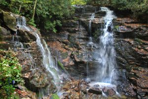
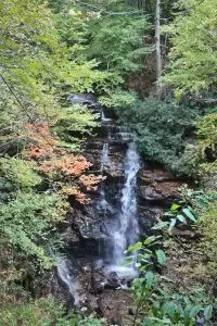
Soco Falls is a 120 foot, double waterfall located between Maggie Valley and Cherokee, just on the edge of the Cherokee Indian Reservation. You can view Soco Falls from several different locations. The first is the observation deck. The trail starts at the break in the guard rail just off the parking area. It takes less than five minutes to walk to the observation deck. There are a few tall steps that take you down to the trail. My little guy needed some assistance here as the steps gave his little legs an issue. Follow the trail down to where it forks. Go to the right to view Soco Falls from the observation deck. This gives you a really good view, so if you are uncertain as to if you want to try the more difficult part of the trail then simply enjoy the spectacular view from here.

It is worth noting that the second waterfall and the very top of the other waterfall are mostly obstructed. However, the view is still quite beautiful. I would rate the trail to the observation deck as easy during good weather conditions.

Soco Falls as viewed from the observation deck

For a closer view, continue down a steep trail from the deck to the base of the waterfalls. This section is steep and downhill. A system of ropes has been set up to help you climb to the base of Soco Falls and return to your car afterward. I have short legs and had to rely heavily on the ropes both climbing down and back up. I would rate this section of the trail as moderate in good weather conditions. If it has rained recently then I would rate it as difficult. There’s a section about halfway down where you can view the waterfall without going all the way to the base if it is too crowded. Once you have viewed Soco Falls, return the way you came.

From Maggie Valley, take Highway 19 south to the Blue Ridge Parkway (from the Soco Gap Milepost 455.7). Cross under the Blue Ridge Parkway and continue downhill on Highway 19 toward Cherokee. After you pass the Parkway, it’s 1.5 miles to an unmarked pullout on the left side of the road. It is easy to miss so watch carefully when close. Parking is limited, only about 10 cars can fit. Just before you reach the parking area, you’ll see a small blue sign with Soco Falls 0.5 miles ahead written on it, however it’s actually 0.3 miles from that sign according to my odometer. While you’re in the area, you might want to check out Mingo Falls (located nearby in Cherokee).

This waterfall gets pretty busy, so you might want to visit early in the morning or during off peak times of the year. The trail can be slippery if it has rained recently, so make sure you wear good hiking shoes.

Share:

  • Click to share on Facebook (Opens in new window) Facebook
  • Click to share on X (Opens in new window) X
  • Click to share on WhatsApp (Opens in new window) WhatsApp
  • Click to share on Pinterest (Opens in new window) Pinterest
  • More
  • Click to share on Pocket (Opens in new window) Pocket
  • Click to share on Tumblr (Opens in new window) Tumblr
  • Click to share on Reddit (Opens in new window) Reddit
  • Click to print (Opens in new window) Print

Like this:

Like Loading...

Related

Directions

From Maggie Valley, take Hwy 19 south to the Blue Ridge Parkway. Cross under the Blue Ridge Parkway and continue downhill on Hwy 19 toward Cherokee. After you pass the Parkway, it's 1.5 miles to an unmarked pullout on the left side of the road. Parking is limited. Just before you reach the parking area, you'll see a small blue sign with Soco Falls 0.5 miles ahead written on it, however it's actually 0.3 miles from that sign according to my odometer.

GPS Coordinates

To the Waterfall:35.492421, -83.169676

Nearby Areas: Blue Ridge Parkway, Cherokee, Cherokee Indian Reservation, Maggie Valley

State: North Carolina

Ease of Trail: Easy, Moderate

Leave a ReplyCancel reply

Recently Added Waterfalls

  • Meadow Branch Cascades
    Meadow Branch Cascades
    State: Tennessee
    Trail Ease: Roadside
  • Whiteoak Flats Branch Falls
    Whiteoak Flats Branch Falls
    State: Tennessee
    Trail Ease: Roadside
  • Twin Falls
    Cane Creek Twin Falls
    State: Tennessee
    Trail Ease: Easy, Roadside
  • Machine Falls
    Machine Falls
    State: Tennessee
    Trail Ease: Easy, Moderate
  • Rutledge Falls at the base
    Rutledge Falls
    State: Tennessee
    Trail Ease: Easy

Recently Added Trips

  • The Sinks 2
    Smoky Mountain Roadside Waterfall Day Trip
  • Little Egypt Falls
    Wartburg Area Waterfall Day Trip
  • Rutledge Falls at the base
    Tullahoma Family Friendly Waterfall Day Trip
  • Lower Greeter Falls in the Spring
    South Central Tennessee 3-5 Day Trip
  • Full length of Pine Ridge Falls
    Erwin Area Waterfall Day Trip
  • Upper Falls Graveyard Fields
    Blue Ridge Parkway to Highlands Road Trip
  • City Lake Falls
    Southeast Tennessee: Cookeville to Tellico Plains 3-5 Day Waterfall Road Trip

Fall Trails by Difficulty

  • Easy (103 trails)
  • Moderate (42 trails)
  • Wheelchair Accessible (9 trails)
  • Roadside (40 trails)
  • Strenuous (9 trails)

Waterfalls by State

  • Georgia (5 trails)
  • South Carolina (9 trails)
  • North Carolina (47 trails)
  • Tennessee (71 trails)
  • Virginia (8 trails)
  • Kentucky (4 trails)

Copyright Info
Privacy Policy

Supporting the Site
Disclaimer & Info
About the Authors
Wesite developed by Waltdesign & Development.
%d