Southeast Waterfall & Hiking Guide

Your Hiking Guide to Waterfalls and more in the Southeast US

  • Home
  • About
  • Ease of Trail
    • Roadside
    • Wheelchair Accessible
    • Easy
    • Moderate
    • Strenuous/Hard
  • Fall Location
    • Georgia
    • North Carolina
    • South Carolina
    • Kentucky
    • Tennessee
    • Virginia
  • Waterfall Trips
    • Day Trip
    • 3 to 5 Day Trip
  • Area Attractions
    • Bridges
  • Hiking
  • Blog
    • News
    • Photography
  • Terms to Know
Home

Spring Falls (inside Pinnacle Natural Area Preserve)

Posted on March 23, 2021 Written by Leave a Comment

Nearby Areas: Abingdon, Big Falls, Lebanon, Pinnacle Natural Area   State: Virginia   Ease of Trail: Easy

Spring Falls is located inside the Pinnacle Natural Area Preserve. If you are looking for a longer family friendly hike on an easy trail, then this waterfall is for you.

From the good sized parking lot, you will start your hike by walking up steps and crossing a suspension bridge. It swings pretty easily, especially if you have kids with you.

Upon crossing you will be on the Big Cedar Creek Trail, which starts out pretty narrow, but widens to become a large gravel covered trail. The trail takes you alongside Big Cedar Creek almost the entire way. Please note that after prolonged heavy rains the trail can flood at the beginning, as had occurred on our trip. However, we were able to climb alongside the trail and still pass.

At 0.4 miles the Big Cedar Creek Trail intersects with the Grapevine Hill Trail on your left. Continue straight on the wide blue-blazed trail continuing alongside the creek.

In another half-mile, you’ll see a second trail junction with a large preserve map sign. There is also a post behind it with the trail names and blaze colors with the distance to each trail from this point. Up ahead you will see pit toilets and a picnic shelter.

Continue straight ahead on the trail until the trail dead ends at the picnic shelter. Just behind the picnic shelter with a post marking the trailhead with a green sign for Spring Falls Trail.

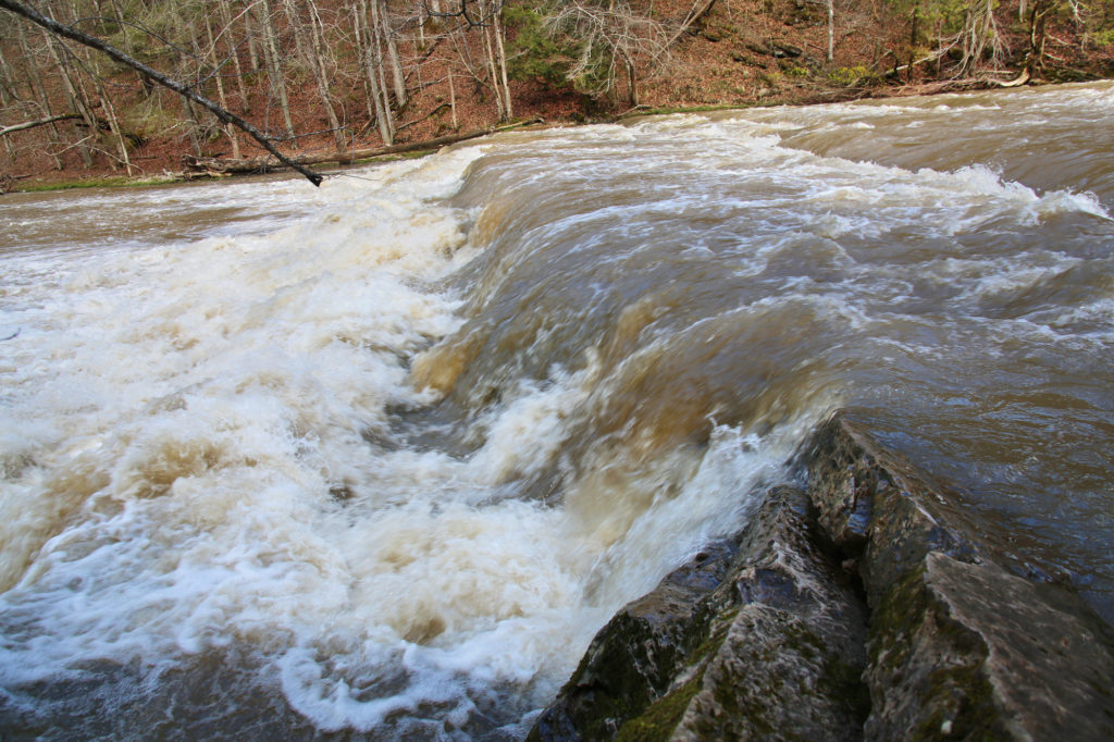
Follow the green blazed trail to Spring Falls, which is an easy 0.25 mile hike that winds through a wooded area next to the creek. It is almost entirely flat the whole way except a few stone steps toward the end that take you to the waterfall. You’ll emerge just next to the top/side of Spring Falls.

After viewing the waterfall, you return the way you came to exit the park.

However, before you leave you may want to visit Big Falls (an impressive waterfall that spans the entire width of the large creek) and the Pinnacle (the preserve’s namesake), which are only located a short distance away. To view Big Falls, return to the junction with the reserve sign just past the restrooms. Turn right on Big Cedar Creek Trail. Continue following the trail until you reach a small side trail taking you to the base of Big Falls. To view the Pinnacle, continue down the Big Cedar Creek Trail to another trail junction at approximately 1.4 miles. The main trail heads to the left here, while the Pinnacle View Trail forks off to the right. After viewing the Pinnacle return the way you came on Big Cedar Creek trail. At the junction with the preserve sign, turn right to exit the park.

Spring Falls

Share:

  • Click to share on Facebook (Opens in new window) Facebook
  • Click to share on X (Opens in new window) X
  • Click to share on WhatsApp (Opens in new window) WhatsApp
  • Click to share on Pinterest (Opens in new window) Pinterest
  • More
  • Click to share on Pocket (Opens in new window) Pocket
  • Click to share on Tumblr (Opens in new window) Tumblr
  • Click to share on Reddit (Opens in new window) Reddit
  • Click to print (Opens in new window) Print

Like this:

Like Loading...

Related

Directions

From I-81 in Abingdon, take Alt 58 West to U.S. Route 19 North. Go about 20 miles and get off at the Business 19 exit into Lebanon. Turn left. At the second light, turn left onto Route 82 West. Go 1.1 miles to Route 640 (River Mountain Road) and turn right. Go 4.2 miles and turn left on Route 721 (gravel road). Go 0.8 mile to the parking area on the left.

Nearby Areas: Abingdon, Big Falls, Lebanon, Pinnacle Natural Area

State: Virginia

Ease of Trail: Easy

Leave a ReplyCancel reply

Recently Added Waterfalls

  • Meadow Branch Cascades
    Meadow Branch Cascades
    State: Tennessee
    Trail Ease: Roadside
  • Whiteoak Flats Branch Falls
    Whiteoak Flats Branch Falls
    State: Tennessee
    Trail Ease: Roadside
  • Twin Falls
    Cane Creek Twin Falls
    State: Tennessee
    Trail Ease: Easy, Roadside
  • Machine Falls
    Machine Falls
    State: Tennessee
    Trail Ease: Easy, Moderate
  • Rutledge Falls at the base
    Rutledge Falls
    State: Tennessee
    Trail Ease: Easy

Recently Added Trips

  • The Sinks 2
    Smoky Mountain Roadside Waterfall Day Trip
  • Little Egypt Falls
    Wartburg Area Waterfall Day Trip
  • Rutledge Falls at the base
    Tullahoma Family Friendly Waterfall Day Trip
  • Lower Greeter Falls in the Spring
    South Central Tennessee 3-5 Day Trip
  • Full length of Pine Ridge Falls
    Erwin Area Waterfall Day Trip
  • Upper Falls Graveyard Fields
    Blue Ridge Parkway to Highlands Road Trip
  • City Lake Falls
    Southeast Tennessee: Cookeville to Tellico Plains 3-5 Day Waterfall Road Trip

Fall Trails by Difficulty

  • Easy (103 trails)
  • Moderate (42 trails)
  • Wheelchair Accessible (9 trails)
  • Roadside (40 trails)
  • Strenuous (9 trails)

Waterfalls by State

  • Georgia (5 trails)
  • South Carolina (9 trails)
  • North Carolina (47 trails)
  • Tennessee (71 trails)
  • Virginia (8 trails)
  • Kentucky (4 trails)

Copyright Info
Privacy Policy

Supporting the Site
Disclaimer & Info
About the Authors
Wesite developed by Waltdesign & Development.
%d