Southeast Waterfall & Hiking Guide

Your Hiking Guide to Waterfalls and more in the Southeast US

  • Home
  • About
  • Ease of Trail
    • Roadside
    • Wheelchair Accessible
    • Easy
    • Moderate
    • Strenuous/Hard
  • Fall Location
    • Georgia
    • North Carolina
    • South Carolina
    • Kentucky
    • Tennessee
    • Virginia
  • Waterfall Trips
    • Day Trip
    • 3 to 5 Day Trip
  • Area Attractions
    • Bridges
  • Hiking
  • Blog
    • News
    • Photography
  • Terms to Know
Home

Upper Creek Falls

Posted on December 11, 2023 Written by 4 Comments

Nearby Areas: Blue Ridge Parkway, Linville Falls, Pisgah National Forest   State: North Carolina   Ease of Trail: Moderate, Strenuous

Top of Upper Creek Falls

Upper Creek Falls is pretty waterfall located in the Pisgah National Forest. If you are driving on the Blue Ridge Parkway in the Linville Falls area, this waterfall is worth a short trip off the Parkway.

The trail starts just behind and to the left of the park sign with information about the waterfall and trail. At the beginning, the trail starts out mostly level and runs parallel to NC 181, then moves away and descends on switchbacks. There are many roots protruding into the trail path so watch your step.

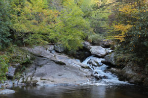
At 0.38 miles you will come to a set of steps crossing over to the creek. This will bring you to the top of Upper Creek Falls and the view in the photo above.

Cross the creek (not a simple crossing, your shoes will most likely get wet) and follow the path downstream. Stay to the left on the main trail. This will bring you to the middle of the waterfall.

To reach the base continue downstream on the trail. Stay on the main path until you reach an obvious wide path leading to the base. You will need to climb up beside the cascade on a huge boulder to get a good view, but it’s worth it.

To continue to Lower Falls, head downstream, staying on the main path. After a little over 0.1 miles, you’ll come to Lower Falls. Cross stream to continue the loop and return to the parking lot.


Share:

  • Click to share on Facebook (Opens in new window) Facebook
  • Click to share on X (Opens in new window) X
  • Click to share on WhatsApp (Opens in new window) WhatsApp
  • Click to share on Pinterest (Opens in new window) Pinterest
  • More
  • Click to share on Pocket (Opens in new window) Pocket
  • Click to share on Tumblr (Opens in new window) Tumblr
  • Click to share on Reddit (Opens in new window) Reddit
  • Click to print (Opens in new window) Print

Like this:

Like Loading...

Related

Directions

NC 181 crosses the Blue Ridge Parkway at MP 312. From there head south on NC 181 (NC 131) for 5.65 miles to the signed trailhead on the left near mile marker 22. The turn off is easy to pass, so start looking about a mile out for the brown Pisgah National Forest sign denoting the entrance to the parking area for Upper Creek Falls. A short drive leads to a large gravel parking area. GPS coordinates for the entrance to the parking area: Latitude : 35.95933 (35° 57′ 33.58″ N), Longitude : -81.8609 (81° 51′ 39.24″ W)

GPS Coordinates

To the Trailhead:35.95994 (35° 57′ 35.79″ N), -81.86103 (81° 51′ 39.71″ W)

To the Waterfall:35.96022 (35° 57′ 36.81″ N), -81.86366 (81° 51′ 49.19″ W)

Nearby Areas: Blue Ridge Parkway, Linville Falls, Pisgah National Forest

State: North Carolina

Ease of Trail: Moderate, Strenuous

Comments

  1. Sebastian says

    December 13, 2016 at 10:20 PM

    I love your site! I never realized how many waterfalls were so close to the Blue Ridge Parkway until I started reading your site. Thank you for sharing your knowledge with us.

    Reply
  2. Evelyn says

    December 29, 2016 at 4:18 AM

    I’ve never gone into the Pisgah National Forest before. I’ve been in the Smokies and the Blue Ridge Parkway. I’ve noticed that you have a few from Pisgah on your site, and decided to check this one out. There wasn’t much parking, but the trail is really easy to find. The trail was also well maintained like in the Smokies and the Blue Ridge. I really enjoyed the hike as it wasn’t as busy as most of them are in the other parks.

    Reply
  3. Alison says

    January 20, 2017 at 9:47 PM

    The top is really pretty, but the trail down to the bottom falls is pretty difficult. I tried, but had to turn around. It tricks you because it starts out so easy, but after you pass the first waterfall it gets harder really quickly.

    Reply
  4. Jennifer says

    February 3, 2017 at 10:28 PM

    This is a great hike! I go on the Blue Ridge all the time and had never heard of this one, so I decided to check it out since it was so close by. Thanks for letting me know!

    Reply

Leave a ReplyCancel reply

Recently Added Waterfalls

  • Logan Creek Falls (also known as Falls Of Logan Creek)
    State: Virginia
    Trail Ease: Easy
  • Meadow Branch Cascades
    Meadow Branch Cascades
    State: Tennessee
    Trail Ease: Roadside
  • Whiteoak Flats Branch Falls
    Whiteoak Flats Branch Falls
    State: Tennessee
    Trail Ease: Roadside
  • Twin Falls
    Cane Creek Twin Falls
    State: Tennessee
    Trail Ease: Easy, Roadside
  • Machine Falls
    Machine Falls
    State: Tennessee
    Trail Ease: Easy, Moderate

Recently Added Trips

  • The Sinks 2
    Smoky Mountain Roadside Waterfall Day Trip
  • Little Egypt Falls
    Wartburg Area Waterfall Day Trip
  • Rutledge Falls at the base
    Tullahoma Family Friendly Waterfall Day Trip
  • Lower Greeter Falls in the Spring
    South Central Tennessee 3-5 Day Trip
  • Full length of Pine Ridge Falls
    Erwin Area Waterfall Day Trip
  • Upper Falls Graveyard Fields
    Blue Ridge Parkway to Highlands Road Trip
  • City Lake Falls
    Southeast Tennessee: Cookeville to Tellico Plains 3-5 Day Waterfall Road Trip

Fall Trails by Difficulty

  • Easy (104 trails)
  • Moderate (42 trails)
  • Wheelchair Accessible (9 trails)
  • Roadside (40 trails)
  • Strenuous (9 trails)

Waterfalls by State

  • Georgia (5 trails)
  • South Carolina (9 trails)
  • North Carolina (47 trails)
  • Tennessee (71 trails)
  • Virginia (9 trails)
  • Kentucky (4 trails)

Copyright Info
Privacy Policy

Supporting the Site
Disclaimer & Info
About the Authors
Wesite developed by Waltdesign & Development.
%d