Southeast Waterfall & Hiking Guide

Your Hiking Guide to Waterfalls and more in the Southeast US

  • Home
  • About
  • Ease of Trail
    • Roadside
    • Wheelchair Accessible
    • Easy
    • Moderate
    • Strenuous/Hard
  • Fall Location
    • Georgia
    • North Carolina
    • South Carolina
    • Kentucky
    • Tennessee
    • Virginia
  • Waterfall Trips
    • Day Trip
    • 3 to 5 Day Trip
  • Area Attractions
    • Bridges
  • Hiking
  • Blog
    • News
    • Photography
  • Terms to Know
Home

Waterfall at Rough Ridge Trail

Posted on May 24, 2021 Written by Leave a Comment

Nearby Areas: Blowing Rock, Blue Ridge Parkway, Linn Cove Viaduct, Linville, Linville Falls   State: North Carolina   Ease of Trail: Roadside

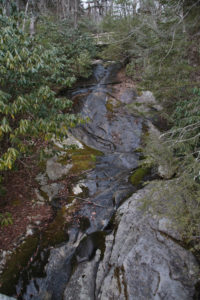
The Waterfall at Rough Ridge Trail is located at milepost 302.8 on the Blue Ridge Parkway. This waterfall is best viewed after heavy rains. Most of the time there is hardly any water flow, as was the time when we last visited in March 2021.

However, even if the waterfall is not visible when you visit, Rough Ridge Trail has some of the best views in the area and well worth a visit. The trail begins to the right of the parking area, just past the waterfall. You begin the trail on a rocky staircase and cross the bridge above the waterfall.  Pets are not allowed on the trail past this point due to a protected critical and highly vulnerable plant community.

There are amazing views of Grandfather Mountain and Linn Cove Viaduct. The moderate/strenuous trail gets more difficult as you go, so most people turn around at the boardwalk located 1/3 of a mile into the hike.


Share:

  • Click to share on Facebook (Opens in new window) Facebook
  • Click to share on X (Opens in new window) X
  • Click to share on WhatsApp (Opens in new window) WhatsApp
  • Click to share on Pinterest (Opens in new window) Pinterest
  • More
  • Click to share on Pocket (Opens in new window) Pocket
  • Click to share on Tumblr (Opens in new window) Tumblr
  • Click to share on Reddit (Opens in new window) Reddit
  • Click to print (Opens in new window) Print

Like this:

Like Loading...

Related

Directions

From Blowing Rock: Head south on Main St. Turn right onto US 221(Yonahlossee Road). Turn right onto SR 1552. Turn right onto SR 1571. Turn left onto Blue Ridge Parkway. Park at Rough Ridge Overlook (milepost 302.8) on your right.

GPS Coordinates

To the Trailhead:36.098350, -81.797027

Nearby Areas: Blowing Rock, Blue Ridge Parkway, Linn Cove Viaduct, Linville, Linville Falls

State: North Carolina

Ease of Trail: Roadside

Leave a ReplyCancel reply

Recently Added Waterfalls

  • Meadow Branch Cascades
    Meadow Branch Cascades
    State: Tennessee
    Trail Ease: Roadside
  • Whiteoak Flats Branch Falls
    Whiteoak Flats Branch Falls
    State: Tennessee
    Trail Ease: Roadside
  • Twin Falls
    Cane Creek Twin Falls
    State: Tennessee
    Trail Ease: Easy, Roadside
  • Machine Falls
    Machine Falls
    State: Tennessee
    Trail Ease: Easy, Moderate
  • Rutledge Falls at the base
    Rutledge Falls
    State: Tennessee
    Trail Ease: Easy

Recently Added Trips

  • The Sinks 2
    Smoky Mountain Roadside Waterfall Day Trip
  • Little Egypt Falls
    Wartburg Area Waterfall Day Trip
  • Rutledge Falls at the base
    Tullahoma Family Friendly Waterfall Day Trip
  • Lower Greeter Falls in the Spring
    South Central Tennessee 3-5 Day Trip
  • Full length of Pine Ridge Falls
    Erwin Area Waterfall Day Trip
  • Upper Falls Graveyard Fields
    Blue Ridge Parkway to Highlands Road Trip
  • City Lake Falls
    Southeast Tennessee: Cookeville to Tellico Plains 3-5 Day Waterfall Road Trip

Fall Trails by Difficulty

  • Easy (103 trails)
  • Moderate (42 trails)
  • Wheelchair Accessible (9 trails)
  • Roadside (40 trails)
  • Strenuous (9 trails)

Waterfalls by State

  • Georgia (5 trails)
  • South Carolina (9 trails)
  • North Carolina (47 trails)
  • Tennessee (71 trails)
  • Virginia (8 trails)
  • Kentucky (4 trails)

Copyright Info
Privacy Policy

Supporting the Site
Disclaimer & Info
About the Authors
Wesite developed by Waltdesign & Development.
%d