Yahoo Falls, a seasonal waterfall located in Big South Fork National Recreation Area, is 113 feet high. Many people consider Yahoo Falls to be the tallest waterfall in Kentucky. (A similar waterfall in the Red River Gorge is said to exceed Yahoo Falls in height by a few inches.).
We were able to find Yahoo Falls without difficulty. There is a large parking area near the trailhead that has picnic and restroom facilities.
On the day we visited the trail was extremely busy due to The Yamacraw Trail Run Race (A 40 Mile Ultra Marathon) that runs through the Yahoo Falls trail. It was fun cheering on the runners while we explored the trail.
The Trail
At the head of the trail, there was a sign describing the trail options. Since it was a muddy day, we decided to just visit the waterfall and save the arch for another day. (If you decide to add Yahoo Arch, it’s an out and back trail that will add 1.6 miles to your trip.)
Please note: Timber rattlesnakes and copperheads can be found in the region.
The sign mentioned a shorter trail to the left of the junction. A short distance onto the trail, there is a spur to the left. This takes you to an overlook of Big South Fork, with no views of the waterfall. After making this mistake, we returned to the trail to see the waterfall. Luckily, it’s a short offshoot, so if you enjoy looking at the valley, you may want to take this slight detour and see a little more.
The Overlook
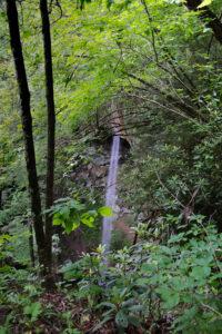
We continued down the trail until we reached another sign where the trail splits. If you go to the right, you will reach an overlook where you can see Yahoo Falls through the trees. After checking out the view from the overlook.
You can see the fall from the overlook in the photo to the right.
After we viewed the overlook, we then returned to the sign where the trail splits and headed toward the left.
Follow the trail until you reach a large set of metal stairs (150+ steps) going down to the waterfall. In the Spring there is a lush landscape of hemlock, white pine, mountain laurel and rhododendron all around you. The trail is a little narrow in parts and runs alongside some interesting rock formations.
At this point, the trail became really muddy and slippery because of the recent rains in the area. However, we were able to get through without incident.
Getting to the Fall
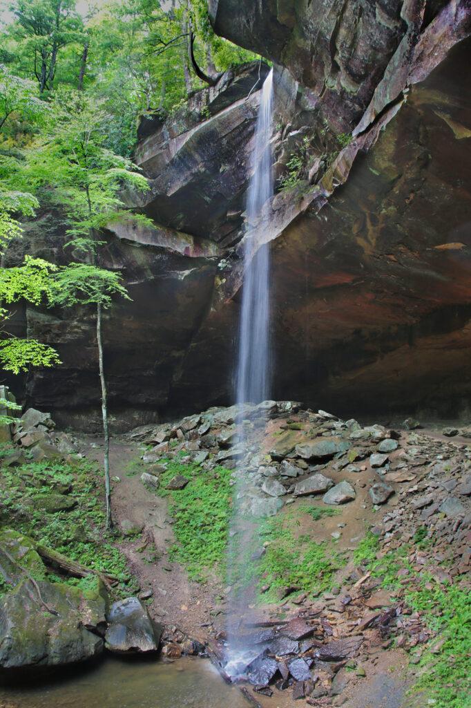
After winding around for a little bit, you’ll come up to Yahoo Falls off to your left side. This is one of the better places to take photos if you want to get the whole waterfall in the photo.
Behind Yahoo Falls is an impressive rock shelter (also called a rock house), one of the nearly 6000 rock shelters within the Big South Fork. The cliffs and rock shelter are streaked with varying shades of red, orange, tan and black. This gives the waterfall a colorful and beautiful backdrop.
There are steps that lead down to the base of the waterfall. There is only a shallow pool at the base of the waterfall, so don’t expect to go swimming, but we saw several families splashing in the water.
From the base, you can take some interesting photos looking upward at the waterfall. You can walk behind the waterfall at the base and also from the trail. After viewing the waterfall, we returned the way we came.
Like many of the waterfalls in the area, Yahoo Falls is reduced to a trickle in the summer. So while the scenery is great all year, Yahoo Falls is best viewed in the spring or after a big rain, when the volume is at its highest.
The trail stays shaded throughout the year, making for great photos and reducing the chances of overheating.
The hike to the overlook will only take a few minutes and is an easy hike, however in the Spring it sometimes can be obscured by the foliage.
I rated the hike as a moderate to go to the base of the waterfall due to the stairs and the muddy conditions that will be present during the best viewing times of the waterfall.
Leave a Reply