Southeast Waterfall & Hiking Guide

Your Hiking Guide to Waterfalls and more in the Southeast US

  • Home
  • About
  • Ease of Trail
    • Roadside
    • Wheelchair Accessible
    • Easy
    • Moderate
    • Strenuous/Hard
  • Fall Location
    • Georgia
    • North Carolina
    • South Carolina
    • Kentucky
    • Tennessee
    • Virginia
  • Waterfall Trips
    • Day Trip
    • 3 to 5 Day Trip
  • Area Attractions
    • Bridges
  • Hiking
  • Blog
    • News
    • Photography
  • Terms to Know
Home

Discovery Falls

Posted on September 1, 2022 Written by Leave a Comment

Nearby Areas: Brevard, Cedar Rock Falls, Daniel Ridge Falls, Log Hollow Falls, Logging Road Falls, Looking Glass Falls, Moore Cove Falls, Pisgah National Forest, Slick Rock Falls, Upper Log Hollow Falls   State: North Carolina   Ease of Trail: Strenuous

Discovery Falls is a beautiful 75 foot waterfall located in the Pisgah National Forest, near Brevard, well-known as the Land of Waterfalls. It is located just off the main trail for Log Hollow Falls. This trail contains hikes to four waterfalls, including Discovery Falls. Many people list Discovery Falls as a moderate 1 mile round trip hike, however I would classify it as a strenuous one given the trail conditions being unmaintained. There are several downed trees blocking the trail and parts of the trail are steep and very slippery when muddy.

You park right in front of the gated road, located on a sharp left turn where you will see a large informative forest sign. There are two options available from the parking area – a trail leading up into the woods and the gated FS5042. You’ll want to walk around the gate and follow the service road trail into a large open area.

The trail starts out very easy and follows the wide and well maintained forest road.  After walking through a small field you will reach a wooden bridge.  This will be the first bridge on the trail. Just before the bridge is a trail on the right side, which will heads upstream to Discovery Falls.

From this point to the base of the waterfall it is all uphill. When the ground is dry, the first part of this side trail isn’t too bad, however if it is muddy it can be very slippery. This part of the trail leading to Discovery Falls is not maintained and the past two times we’ve hiked this trail there was a large downed tree and it was difficult to navigate the trail from this point on. Our seven-year-old son was unable to continue from this point. As you get closer to the waterfall the trail continues to get steeper and steeper until you reach the base of the falls.

This is an out and back hike so when you have finished viewing Discovery Falls, return to the main trail the way you came. Before visiting Discovery Falls, check ahead and make sure you can reach this waterfall as sometimes the connecting roads may be closed due to snow (especially from January to March) or flooding in the area.

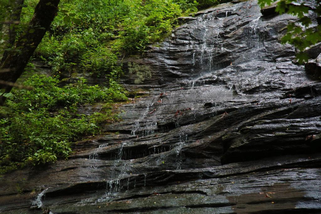
Discovery Falls is best viewed after a good rainfall, however even not at its best water flow it is still pretty. The photo taken below was during the summer when water flow wasn’t as high as in the spring. This area is remote and there are no restroom facilities at the trailhead.

If you would like to extend your hike you can return to the main trail and continue to the second bridge where you will see Log Hollow Falls on your right, viewable from the trail. Cross the bridge and you will see a trail on the right that will lead to the base of Log Hollow Falls. From there you can continue to a side view of Upper Log Hollow Falls by taking the trail on the left of the base of Log Hollow Falls. After viewing Upper Log Hollow Falls, return to the main trail and continue up the trail to Logging Road Falls on your right.

While in the area, you may want to check out Looking Glass Falls, Daniel Ridge Falls, Moore Cove Falls, Cedar Rock Falls and Slick Rock Falls.

Discovery Falls

Share:

  • Click to share on Facebook (Opens in new window) Facebook
  • Click to share on X (Opens in new window) X
  • Click to share on WhatsApp (Opens in new window) WhatsApp
  • Click to share on Pinterest (Opens in new window) Pinterest
  • More
  • Click to share on Pocket (Opens in new window) Pocket
  • Click to share on Tumblr (Opens in new window) Tumblr
  • Click to share on Reddit (Opens in new window) Reddit
  • Click to print (Opens in new window) Print

Like this:

Like Loading...

Related

Directions

From Brevard: At the intersection of NC280/US64/US276 drive north on US276 for 10.1 miles and turn left onto FR475B/Headwaters Road, which is a gravel road. Drive 1.6 miles until you come to the 2nd hairpin turn on the left. On the right hand side look for gated forest road 5043 on the right. There are several places to park. Be sure not to block the gate. You'll see a big brown informational sign right by the parking area.

GPS Coordinates

To the Waterfall:35.327096, -82.808805

Nearby Areas: Brevard, Cedar Rock Falls, Daniel Ridge Falls, Log Hollow Falls, Logging Road Falls, Looking Glass Falls, Moore Cove Falls, Pisgah National Forest, Slick Rock Falls, Upper Log Hollow Falls

State: North Carolina

Ease of Trail: Strenuous

Leave a ReplyCancel reply

Recently Added Waterfalls

  • Logan Creek Falls (also known as Falls Of Logan Creek)
    State: Virginia
    Trail Ease: Easy
  • Meadow Branch Cascades
    Meadow Branch Cascades
    State: Tennessee
    Trail Ease: Roadside
  • Whiteoak Flats Branch Falls
    Whiteoak Flats Branch Falls
    State: Tennessee
    Trail Ease: Roadside
  • Twin Falls
    Cane Creek Twin Falls
    State: Tennessee
    Trail Ease: Easy, Roadside
  • Machine Falls
    Machine Falls
    State: Tennessee
    Trail Ease: Easy, Moderate

Recently Added Trips

  • The Sinks 2
    Smoky Mountain Roadside Waterfall Day Trip
  • Little Egypt Falls
    Wartburg Area Waterfall Day Trip
  • Rutledge Falls at the base
    Tullahoma Family Friendly Waterfall Day Trip
  • Lower Greeter Falls in the Spring
    South Central Tennessee 3-5 Day Trip
  • Full length of Pine Ridge Falls
    Erwin Area Waterfall Day Trip
  • Upper Falls Graveyard Fields
    Blue Ridge Parkway to Highlands Road Trip
  • City Lake Falls
    Southeast Tennessee: Cookeville to Tellico Plains 3-5 Day Waterfall Road Trip

Fall Trails by Difficulty

  • Easy (104 trails)
  • Moderate (42 trails)
  • Wheelchair Accessible (9 trails)
  • Roadside (40 trails)
  • Strenuous (9 trails)

Waterfalls by State

  • Georgia (5 trails)
  • South Carolina (9 trails)
  • North Carolina (47 trails)
  • Tennessee (71 trails)
  • Virginia (9 trails)
  • Kentucky (4 trails)

Copyright Info
Privacy Policy

Supporting the Site
Disclaimer & Info
About the Authors
Wesite developed by Waltdesign & Development.
%d