Southeast Waterfall & Hiking Guide

Your Hiking Guide to Waterfalls and more in the Southeast US

  • Home
  • About
  • Ease of Trail
    • Roadside
    • Wheelchair Accessible
    • Easy
    • Moderate
    • Strenuous/Hard
  • Fall Location
    • Georgia
    • North Carolina
    • South Carolina
    • Kentucky
    • Tennessee
    • Virginia
  • Waterfall Trips
    • Day Trip
    • 3 to 5 Day Trip
  • Area Attractions
    • Bridges
  • Hiking
  • Blog
    • News
    • Photography
  • Terms to Know
Home

Log Hollow Falls

Posted on October 26, 2021 Written by 1 Comment

Nearby Areas: Blue Ridge Parkway, Brevard, Daniel Ridge Falls, Looking Glass Falls, Moore Cove Falls, Pisgah National Forest   State: North Carolina   Ease of Trail: Easy

Log Hollow Falls From the Base

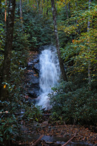
Log Hollow Falls is a pretty 25-30 foot waterfall located in the Pisgah National Forest.  Unlike a lot of the waterfalls in this area, Log Hollow Falls doesn’t get as many visitors. The trail is well defined and follows Forest Service Road 5043 that is closed to vehicles.

You park right in front of the gated road. There are two options available from the parking area – a trail leading up into the woods and the gated FS5042. You’ll want to walk around the gate and follow the service road trail into a large open area.

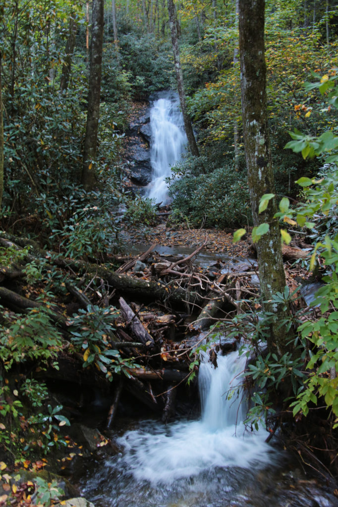
Less than 0.25 miles from the parking area, you will reach the first bridge. Continue past the first bridge up the walkway for another 5 minutes or so to the next bridge. You’ll see Log Hollow Falls on your right.

To see a close up view of Log Hollow Falls from the base, cross the bridge and look for the side trail immediately on your right as soon as you cross the bridge.

To return to the parking area, simply turn around and walk back the way you came. Before visiting Log Hollow Falls, check ahead and make sure you can reach this waterfall as sometimes the connecting roads may be closed due to snow (especially from January to March) or flooding in the area.

While in the area, you may want to check out Looking Glass Falls, Daniel Ridge Falls, Moore Cove Falls, Cedar Rock Falls and Slick Rock Falls. There are several other waterfalls that are off of this main trail that we hope to get back to visit soon, but were unable to this trip due to trail blockage on the Discovery Falls trail. A large tree had fallen in the path and we were unable to  find another path that led to Discovery Falls. We made our way back to the main trail and were able to visit Log Hollow Falls, but it got dark before we could reach Upper Log Hollow Falls and Logging Road Falls. We hope to visit there again soon and will update the website with these falls then.

Log Hollow Falls From the Bridge

Share:

  • Click to share on Facebook (Opens in new window) Facebook
  • Click to share on X (Opens in new window) X
  • Click to share on WhatsApp (Opens in new window) WhatsApp
  • Click to share on Pinterest (Opens in new window) Pinterest
  • More
  • Click to share on Pocket (Opens in new window) Pocket
  • Click to share on Tumblr (Opens in new window) Tumblr
  • Click to share on Reddit (Opens in new window) Reddit
  • Click to print (Opens in new window) Print

Like this:

Like Loading...

Related

Directions

From Brevard: At the intersection of NC280/US64/US276 drive north on US276 for 10.1 miles and turn left onto FR475B/Headwaters Road, which is a gravel road. Drive 1.6 miles until you come to the 2nd hairpin turn on the left. On the right hand side look for gated forest road 5043 on the right. There are several places to park. Be sure not to block the gate. You'll see a big brown informational sign right by the parking area.

GPS Coordinates

To the Waterfall:35.323846, -82.807712

Nearby Areas: Blue Ridge Parkway, Brevard, Daniel Ridge Falls, Looking Glass Falls, Moore Cove Falls, Pisgah National Forest

State: North Carolina

Ease of Trail: Easy

Comments

  1. Joseph says

    January 7, 2022 at 12:16 PM

    Great content! Keep up the good work!

    Reply

Leave a ReplyCancel reply

Recently Added Waterfalls

  • Logan Creek Falls (also known as Falls Of Logan Creek)
    State: Virginia
    Trail Ease: Easy
  • Meadow Branch Cascades
    Meadow Branch Cascades
    State: Tennessee
    Trail Ease: Roadside
  • Whiteoak Flats Branch Falls
    Whiteoak Flats Branch Falls
    State: Tennessee
    Trail Ease: Roadside
  • Twin Falls
    Cane Creek Twin Falls
    State: Tennessee
    Trail Ease: Easy, Roadside
  • Machine Falls
    Machine Falls
    State: Tennessee
    Trail Ease: Easy, Moderate

Recently Added Trips

  • The Sinks 2
    Smoky Mountain Roadside Waterfall Day Trip
  • Little Egypt Falls
    Wartburg Area Waterfall Day Trip
  • Rutledge Falls at the base
    Tullahoma Family Friendly Waterfall Day Trip
  • Lower Greeter Falls in the Spring
    South Central Tennessee 3-5 Day Trip
  • Full length of Pine Ridge Falls
    Erwin Area Waterfall Day Trip
  • Upper Falls Graveyard Fields
    Blue Ridge Parkway to Highlands Road Trip
  • City Lake Falls
    Southeast Tennessee: Cookeville to Tellico Plains 3-5 Day Waterfall Road Trip

Fall Trails by Difficulty

  • Easy (104 trails)
  • Moderate (42 trails)
  • Wheelchair Accessible (9 trails)
  • Roadside (40 trails)
  • Strenuous (9 trails)

Waterfalls by State

  • Georgia (5 trails)
  • South Carolina (9 trails)
  • North Carolina (47 trails)
  • Tennessee (71 trails)
  • Virginia (9 trails)
  • Kentucky (4 trails)

Copyright Info
Privacy Policy

Supporting the Site
Disclaimer & Info
About the Authors
Wesite developed by Waltdesign & Development.
%d