
Southeast Waterfall & Hiking Guide

Your Hiking Guide to Waterfalls and more in the Southeast US

  • Home
  • About
  • Ease of Trail
    • Roadside
    • Wheelchair Accessible
    • Easy
    • Moderate
    • Strenuous/Hard
  • Fall Location
    • Georgia
    • North Carolina
    • South Carolina
    • Kentucky
    • Tennessee
    • Virginia
  • Waterfall Trips
    • Day Trip
    • 3 to 5 Day Trip
  • Area Attractions
    • Bridges
  • Hiking
  • Blog
    • News
    • Photography
  • Terms to Know
Home Trails Pine Ridge Falls

Pine Ridge Falls

Posted on April 3, 2020 Written by 1 Comment

Nearby Areas: Cherokee National Forest, Sill Branch Falls   State: Tennessee   Ease of Trail: Easy

Full length of Pine Ridge Falls

Pine Ridge Falls is a 25 foot waterfall, located in the beautiful Clark’s Creek area of the Cherokee National Forest in Unicoi County, TN. The hike to Pine Ridge is an easy one mile round trip. The trail is well maintained and not too busy. There is one creek crossing that can be tricky when the water’s up. It gave us a little bit of a challenge getting our toddler across when we went, but otherwise he had no problems walking this trail.

You’ll follow the Longarm Branch Trail at the beginning to reach Pine Ridge Falls. You should see the trail sign from the parking area. Take the Longarm Branch Trail and just after you cross the stream the trail forks. Longarm Branch Trail continues right. But you’ll want to take the path to the left to get to Pine Ridge Falls. This will bring you to the base of the waterfall or you can continue up to the top part of the waterfall.

You may encounter other hikers along the way, but the trail is wide enough to allow easy passing as this is an out and back trail and when you get to the waterfall, you’ll have to turn around and return the way you came.

There are many different angles you can photograph this waterfall from, however if you want to photograph the entire waterfall, you will have to walk across a few rocks (your feet may get a little wet, but it’s worth it).

While you are there be sure to check out Sill Branch Falls, just down the road. It also has its own parking area 0.2 miles away.
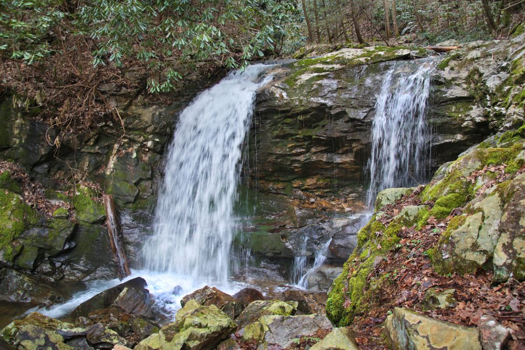
Top portion of Pine Ridge Falls

Share:

  • Share on Facebook (Opens in new window) Facebook
  • Share on X (Opens in new window) X
  • Share on WhatsApp (Opens in new window) WhatsApp
  • Share on Pinterest (Opens in new window) Pinterest
  • More
  • Share on Tumblr (Opens in new window) Tumblr
  • Share on Reddit (Opens in new window) Reddit
  • Print (Opens in new window) Print

Like this:

Like Loading…

Related

Directions

From Route 107, turn left on Clark's Creek Road and drive 3.3 miles (the last 1.9 will be gravel) into the Cherokee National Forest to a parking area on the left. It's 0.2 miles past the parking area for Sill Branch Falls. A small brown sign will indicate the trailhead for "Longarm Branch Trail." From the trailhead, follow the Longarm Branch Trail until just after the stream crossing. Here the trail forks with Longarm Branch Trail continuing right. The path to Pine Ridge Falls is to the left leading up a hill that brings you to the base of Pine Ridge Falls.

GPS Coordinates

To the Waterfall:N 36° 7.518', W 082° 32.264'

Nearby Areas: Cherokee National Forest, Sill Branch Falls

State: Tennessee

Ease of Trail: Easy

Comments

  1. Fred says

    May 23, 2020 at 1:39 AM

    My spouse and I love hiking to waterfalls. We are planning on taking a trip to Tennessee hopefully in the not to distant future. We are looking forward to hiking this as well as several other trails you have listed on your webpage. Many thanks for everything!

    Reply

Leave a ReplyCancel reply

Recently Added Waterfalls

  • Bullpen Cove Falls
    State: North Carolina
    Trail Ease: Roadside
  • Buffalo Springs Falls
    State: Tennessee
    Trail Ease: Easy, Roadside
  • Glen Falls
    State: Tennessee
    Trail Ease: Moderate
  • Vickery Creek Falls/Dam
    State: Georgia
    Trail Ease: Easy
  • Waterfall Park (Dalton, GA)
    State: Georgia
    Trail Ease: Easy

Recently Added Trips

  • Rutledge Falls at the base
    Explore Ten Waterfalls In a Day In This Tennessee Waterfall Road Trip
  • The Sinks 2
    Smoky Mountain Roadside Waterfall Day Trip
  • Little Egypt Falls
    Wartburg Area Waterfall Day Trip
  • Rutledge Falls at the base
    Tullahoma Family Friendly Waterfall Day Trip
  • Lower Greeter Falls in the Spring
    South Central Tennessee 3-5 Day Trip
  • Full length of Pine Ridge Falls
    Erwin Area Waterfall Day Trip
  • Upper Falls Graveyard Fields
    Blue Ridge Parkway to Highlands Road Trip

Fall Trails by Difficulty

  • Easy (111 trails)
  • Moderate (43 trails)
  • Wheelchair Accessible (10 trails)
  • Roadside (43 trails)
  • Strenuous (9 trails)

Waterfalls by State

  • Georgia (8 trails)
  • South Carolina (9 trails)
  • North Carolina (48 trails)
  • Tennessee (76 trails)
  • Virginia (9 trails)
  • Kentucky (4 trails)

Copyright Info
Privacy Policy

Supporting the Site
Disclaimer & Info
About the Authors
Wesite developed by Waltdesign & Development.
%d