Southeast Waterfall & Hiking Guide

Your Hiking Guide to Waterfalls and more in the Southeast US

  • Home
  • About
  • Ease of Trail
    • Roadside
    • Wheelchair Accessible
    • Easy
    • Moderate
    • Strenuous/Hard
  • Fall Location
    • Georgia
    • North Carolina
    • South Carolina
    • Kentucky
    • Tennessee
    • Virginia
  • Waterfall Trips
    • Day Trip
    • 3 to 5 Day Trip
  • Area Attractions
    • Bridges
  • Hiking
  • Blog
    • News
    • Photography
  • Terms to Know
Home

Sill Branch Falls

Posted on June 27, 2020 Written by Leave a Comment

Nearby Areas: Erwin, Pine Ridge Falls   State: Tennessee   Ease of Trail: Easy, Moderate

Sill Branch Falls is located in the Clark’s Creek area of the Cherokee National Forest. The parking area is opposite of the trailhead. The trailhead has a signpost and is blazed with blue triangles (going toward the waterfall) or rectangles (returning to the parking area).

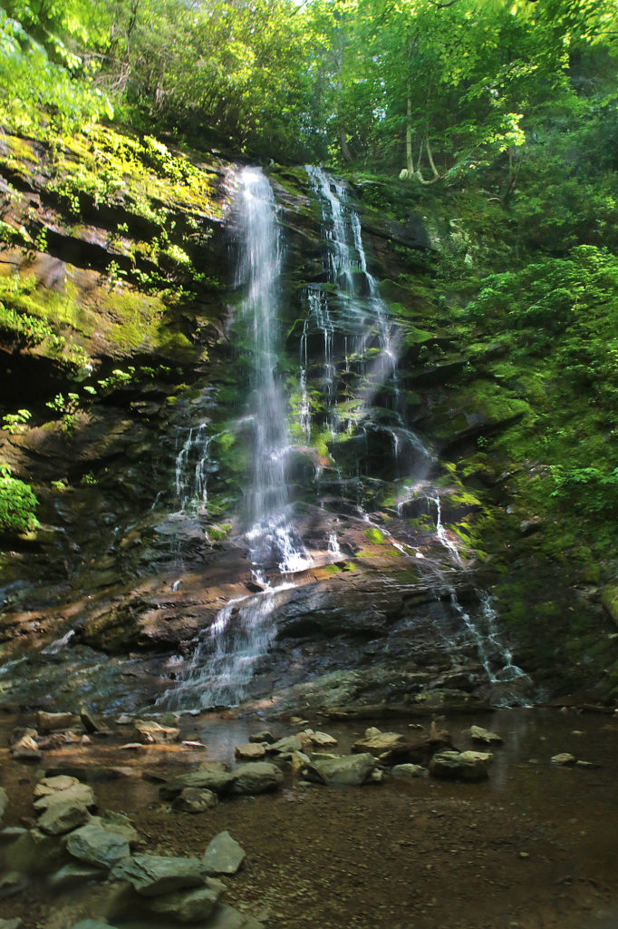
This beautiful 20 foot waterfall starts out with a fairly easy hike with just a tiny incline over slightly rocky terrain with a few roots along the way. It gets a little muddy in a few parts after a good rain, but the mud only goes a tiny bit up on your shoes. Most of the time you can dodge the mud along the sides of the trail.

When the trail forks, make sure you go to the left and you’ll immediately cross a small stream. You’ll see a steep incline on the other side of the stream. There are several places off to the side that go down to the creek, so make sure you don’t turn off too early. Continue up this steep section of the trail and you’ll soon arrive at the waterfall.

You’ll return the way you came to get back to your car. Returning is much easier.

This waterfall is best viewed after a good rain and in the Spring. Also to avoid crowds, earlier in the morning is best. For the best photos I would recommend a cloudy day, as you can see the sun shining in on the photo below and that was taken on a semi-cloudy day with a polarizing filter.

I would rate this waterfall as an easy/moderate since you do have all the rocks and roots to navigate and the one really steep incline.

While in the area, be sure to visit Pine Ridge Falls located 0.2 miles down the road from the parking area to Sill Branch Falls. Look for the entrance to Longarm Branch Trail to make sure you’re in the right place.

Sill Branch Falls

Share:

  • Click to share on Facebook (Opens in new window) Facebook
  • Click to share on X (Opens in new window) X
  • Click to share on WhatsApp (Opens in new window) WhatsApp
  • Click to share on Pinterest (Opens in new window) Pinterest
  • More
  • Click to share on Pocket (Opens in new window) Pocket
  • Click to share on Tumblr (Opens in new window) Tumblr
  • Click to share on Reddit (Opens in new window) Reddit
  • Click to print (Opens in new window) Print

Like this:

Like Loading...

Related

Directions

From Greeneville, take Hwy 107 east for approximately 15 miles. Turn right onto Clark's Creek Road. Drive approximately 3 miles and the trailhead will be on left, about half of this is on a rough road with potholes so drive carefully. The parking area will be on the right.

GPS Coordinates

To the Trailhead:N 36° 7.812', W 082° 32.156' (parking area)

To the Waterfall:36° 7.473' N, 82° 31.630' W

Nearby Areas: Erwin, Pine Ridge Falls

State: Tennessee

Ease of Trail: Easy, Moderate

Leave a ReplyCancel reply

Recently Added Waterfalls

  • Logan Creek Falls (also known as Falls Of Logan Creek)
    State: Virginia
    Trail Ease: Easy
  • Meadow Branch Cascades
    Meadow Branch Cascades
    State: Tennessee
    Trail Ease: Roadside
  • Whiteoak Flats Branch Falls
    Whiteoak Flats Branch Falls
    State: Tennessee
    Trail Ease: Roadside
  • Twin Falls
    Cane Creek Twin Falls
    State: Tennessee
    Trail Ease: Easy, Roadside
  • Machine Falls
    Machine Falls
    State: Tennessee
    Trail Ease: Easy, Moderate

Recently Added Trips

  • The Sinks 2
    Smoky Mountain Roadside Waterfall Day Trip
  • Little Egypt Falls
    Wartburg Area Waterfall Day Trip
  • Rutledge Falls at the base
    Tullahoma Family Friendly Waterfall Day Trip
  • Lower Greeter Falls in the Spring
    South Central Tennessee 3-5 Day Trip
  • Full length of Pine Ridge Falls
    Erwin Area Waterfall Day Trip
  • Upper Falls Graveyard Fields
    Blue Ridge Parkway to Highlands Road Trip
  • City Lake Falls
    Southeast Tennessee: Cookeville to Tellico Plains 3-5 Day Waterfall Road Trip

Fall Trails by Difficulty

  • Easy (104 trails)
  • Moderate (42 trails)
  • Wheelchair Accessible (9 trails)
  • Roadside (40 trails)
  • Strenuous (9 trails)

Waterfalls by State

  • Georgia (5 trails)
  • South Carolina (9 trails)
  • North Carolina (47 trails)
  • Tennessee (71 trails)
  • Virginia (9 trails)
  • Kentucky (4 trails)

Copyright Info
Privacy Policy

Supporting the Site
Disclaimer & Info
About the Authors
Wesite developed by Waltdesign & Development.
%d