Southeast Waterfall & Hiking Guide

Your Hiking Guide to Waterfalls and more in the Southeast US

  • Home
  • About
  • Ease of Trail
    • Roadside
    • Wheelchair Accessible
    • Easy
    • Moderate
    • Strenuous/Hard
  • Fall Location
    • Georgia
    • North Carolina
    • South Carolina
    • Kentucky
    • Tennessee
    • Virginia
  • Waterfall Trips
    • Day Trip
    • 3 to 5 Day Trip
  • Area Attractions
    • Bridges
  • Hiking
  • Blog
    • News
    • Photography
  • Terms to Know
Home

Upper Log Hollow Falls

Posted on September 8, 2022 Written by Leave a Comment

Nearby Areas: Brevard, Daniel Ridge Falls, Discovery Falls, Log Hollow Falls, Logging Road Falls, Looking Glass Falls, Pisgah National Forest   State: North Carolina   Ease of Trail: Easy

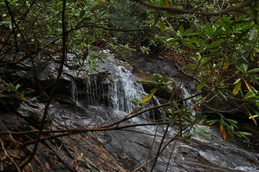
Upper Log Hollow Falls is a pretty 20 foot waterfall located in the Pisgah National Forest, near Brevard. Upper Log Hollow Falls can be accessed by taking the Log Hollow Falls trail, which is well defined and an easy hike.

You park right in front of the gated road, located on a sharp left turn where you will see a large informative forest sign. There are two options available from the parking area – a trail leading up into the woods and the gated FS5042. You’ll want to walk around the gate and follow the service road trail into a large open area.

Less than 0.25 miles from the parking area, you will reach the first bridge. The trail for Discovery Falls is immediately after the bridge on your right. To visit Upper Log Hollow Falls, stay on the main path and continue past the first bridge up the walkway for another 5 minutes or so to the next bridge. You’ll see Log Hollow Falls on your right.

After you view Log Hollow Falls, continue crossing the bridge and look for the side trail immediately on your right as soon as you cross the bridge. This trail leads to the base of Log Hollow Falls. While standing at the base of Log Hollow Falls, look to your left and you’ll see a trail that runs next to Log Hollow Falls. Continue uphill and a short distance up the trail you will see a side view of Upper Log Hollow Falls. After viewing Upper Log Hollow Falls, return to the main trail.

If you would like to extend your hike you can return to the main trail and continue up the trail for another 10 minutes to Logging Road Falls, which is visible from the trail on your right hand side.

To return to the parking area, simply turn around and walk back the way you came. Before visiting Upper Log Hollow Falls, check ahead and make sure you can reach this waterfall as sometimes the connecting roads may be closed due to snow (especially from January to March) or flooding in the area.

This area is remote and there are no restroom facilities at the trailhead. While in the area, you may want to check out Looking Glass Falls, Daniel Ridge Falls, Moore Cove Falls, Cedar Rock Falls and Slick Rock Falls.

Upper Log Hollow Falls

Share:

  • Click to share on Facebook (Opens in new window) Facebook
  • Click to share on X (Opens in new window) X
  • Click to share on WhatsApp (Opens in new window) WhatsApp
  • Click to share on Pinterest (Opens in new window) Pinterest
  • More
  • Click to share on Pocket (Opens in new window) Pocket
  • Click to share on Tumblr (Opens in new window) Tumblr
  • Click to share on Reddit (Opens in new window) Reddit
  • Click to print (Opens in new window) Print

Like this:

Like Loading...

Related

Directions

From Brevard: At the intersection of NC280/US64/US276 drive north on US276 for 10.1 miles and turn left onto FR475B/Headwaters Road, which is a gravel road. Drive 1.6 miles until you come to the 2nd hairpin turn on the left. On the right hand side look for gated forest road 5043 on the right. There are several places to park. Be sure not to block the gate. You'll see a big brown informational sign right by the parking area.

GPS Coordinates

To the Waterfall:35.32453, -82.81147

Nearby Areas: Brevard, Daniel Ridge Falls, Discovery Falls, Log Hollow Falls, Logging Road Falls, Looking Glass Falls, Pisgah National Forest

State: North Carolina

Ease of Trail: Easy

Leave a ReplyCancel reply

Recently Added Waterfalls

  • Meadow Branch Cascades
    Meadow Branch Cascades
    State: Tennessee
    Trail Ease: Roadside
  • Whiteoak Flats Branch Falls
    Whiteoak Flats Branch Falls
    State: Tennessee
    Trail Ease: Roadside
  • Twin Falls
    Cane Creek Twin Falls
    State: Tennessee
    Trail Ease: Easy, Roadside
  • Machine Falls
    Machine Falls
    State: Tennessee
    Trail Ease: Easy, Moderate
  • Rutledge Falls at the base
    Rutledge Falls
    State: Tennessee
    Trail Ease: Easy

Recently Added Trips

  • The Sinks 2
    Smoky Mountain Roadside Waterfall Day Trip
  • Little Egypt Falls
    Wartburg Area Waterfall Day Trip
  • Rutledge Falls at the base
    Tullahoma Family Friendly Waterfall Day Trip
  • Lower Greeter Falls in the Spring
    South Central Tennessee 3-5 Day Trip
  • Full length of Pine Ridge Falls
    Erwin Area Waterfall Day Trip
  • Upper Falls Graveyard Fields
    Blue Ridge Parkway to Highlands Road Trip
  • City Lake Falls
    Southeast Tennessee: Cookeville to Tellico Plains 3-5 Day Waterfall Road Trip

Fall Trails by Difficulty

  • Easy (103 trails)
  • Moderate (42 trails)
  • Wheelchair Accessible (9 trails)
  • Roadside (40 trails)
  • Strenuous (9 trails)

Waterfalls by State

  • Georgia (5 trails)
  • South Carolina (9 trails)
  • North Carolina (47 trails)
  • Tennessee (71 trails)
  • Virginia (8 trails)
  • Kentucky (4 trails)

Copyright Info
Privacy Policy

Supporting the Site
Disclaimer & Info
About the Authors
Wesite developed by Waltdesign & Development.
%d