Southeast Waterfall & Hiking Guide

Your Hiking Guide to Waterfalls and more in the Southeast US

  • Home
  • About
  • Ease of Trail
    • Roadside
    • Wheelchair Accessible
    • Easy
    • Moderate
    • Strenuous/Hard
  • Fall Location
    • Georgia
    • North Carolina
    • South Carolina
    • Kentucky
    • Tennessee
    • Virginia
  • Waterfall Trips
    • Day Trip
    • 3 to 5 Day Trip
  • Area Attractions
    • Bridges
  • Hiking
  • Blog
    • News
    • Photography
  • Terms to Know
Home Trails Laurel Falls (in the Great Smoky Mountains National Park)

Laurel Falls (in the Great Smoky Mountains National Park)

Posted on September 29, 2016 Written by 6 Comments

Nearby Areas: Gatlinburg, Great Smoky Mountains, Pigeon Forge   State: Tennessee   Ease of Trail: Easy, Moderate

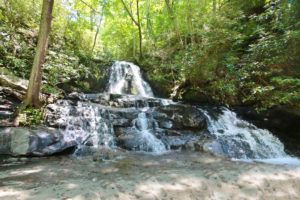
Upper Laurel Falls
Upper section of Laurel Falls

Note: Laurel Falls Trail is closed as of Jan. 6, 2025  for 18 months of rehabilitation work.

Laurel Falls is an extremely popular destination within Great Smoky Mountains National Park due to the fact that it has a paved trail leading up to it. Please note that while this trail is paved, it is not easily traveled by strollers or wheelchairs. There are many sections that have large cracks or gaps that are unpaved.  The hike to Laurel Falls and back is 2.6 miles round trip. Hikers will climb roughly 314 feet in elevation before arriving at the 80-foot waterfall. I would rate this trail easy for your average hikers and moderate for those who are new to hiking or hike infrequently.

The waterfall consists of an upper and a lower section, divided by a walkway which crosses Laurel Branch at the base of the upper falls. For this trip we only visited upper falls, however you can look down from the trail and see lower falls. The falls receives its name from the mountain laurel that blooms along the trail and near the falls in May.

Lower Laurel Falls
Lower section of Laurel Falls as seen from the trail

There are over 800 miles of trail in the Smoky Mountains National Park, but less than 3 miles are paved. Laurel Falls Trail is the longest of four paved trails in the park. The trail was originally built in 1932 to allow fire crews access to the Cove Mountain area in the event of a fire. By the early 1960s, Laurel Falls had become a popular hiking destination and erosion was taking a toll on the trail. As a result, the Laurel Falls Trail was reconditioned, graded, and paved to stop the erosion.

If hiking with children, I recommend keeping a close eye on them at all times as the trail passes next to some very steep drop offs, especially as you get closer to the falls. Some of these drop offs are after blind turns too. This is also bear country and bears have been seen along and near this trail, so please keep your eyes open.

The best time to see Laurel Falls is early in the morning or later in the day. During the midday, the sun creates many hot spots on the waterfall, making it harder to photograph. Plus, the waterfall is busier in the afternoons and it can be harder to photograph with so many people around. Parking can also be a problem during peak season, so if you wish to avoid crowds weekdays or during the off-season would be a better time to visit.

Share:

  • Share on Facebook (Opens in new window) Facebook
  • Share on X (Opens in new window) X
  • Share on WhatsApp (Opens in new window) WhatsApp
  • Share on Pinterest (Opens in new window) Pinterest
  • More
  • Share on Tumblr (Opens in new window) Tumblr
  • Share on Reddit (Opens in new window) Reddit
  • Print (Opens in new window) Print

Like this:

Like Loading…

Related

Directions

From the Sugarlands Visitor Center near Gatlinburg, drive 3.8 miles to the top of Fighting Creek Gap. The parking lot for Laurel Falls will be on your right. The address for Sugarlands Visitor Center is 1420 Fighting Creek Gap Rd, Gatlinburg, TN 37738.

GPS Coordinates

To the Trailhead:Lat: 35.67208, Long: - 83.58068

Nearby Areas: Gatlinburg, Great Smoky Mountains, Pigeon Forge

State: Tennessee

Ease of Trail: Easy, Moderate

Comments

  1. Rex says

    October 14, 2016 at 12:18 AM

    I was extremely pleased to discover this page. I need to to thank you for helping make planning my family’s vacation so much easier. I like the searchability on your page. I have bookmarked it to help me with future vacations.

    Reply
    • Tracy says

      October 18, 2016 at 6:58 AM

      Thank you Rex! Glad to help. Keep checking back for additional waterfalls!

      Reply
  2. Kelly says

    October 14, 2016 at 10:40 AM

    Such a pretty waterfall. Thank you for the details about it. This one has always been one I’ve heard about but never seen. Hopefully one day I’ll see it too.

    Reply
  3. Lina says

    March 28, 2019 at 5:15 PM

    Wonderful blog! I love reading about waterfalls such as this one. Hopefully I’ll make it out to the Smoky Mountains one day. Until then at least I can enjoy them through your site.

    Reply
  4. Ella says

    April 29, 2019 at 9:20 PM

    Way cool waterfall! I highly recommend it!

    Reply
  5. Terry says

    March 7, 2020 at 12:15 PM

    This is one of my favorite waterfalls in the Smokies. Keep a lookout as bears are sometimes in this area, but otherwise a great fall to share with the kids.

    Reply

Leave a ReplyCancel reply

Recently Added Waterfalls

  • Bullpen Cove Falls
    State: North Carolina
    Trail Ease: Roadside
  • Buffalo Springs Falls
    State: Tennessee
    Trail Ease: Easy, Roadside
  • Glen Falls
    State: Tennessee
    Trail Ease: Moderate
  • Vickery Creek Falls/Dam
    State: Georgia
    Trail Ease: Easy
  • Waterfall Park (Dalton, GA)
    State: Georgia
    Trail Ease: Easy

Recently Added Trips

  • Rutledge Falls at the base
    Explore Ten Waterfalls In a Day In This Tennessee Waterfall Road Trip
  • The Sinks 2
    Smoky Mountain Roadside Waterfall Day Trip
  • Little Egypt Falls
    Wartburg Area Waterfall Day Trip
  • Rutledge Falls at the base
    Tullahoma Family Friendly Waterfall Day Trip
  • Lower Greeter Falls in the Spring
    South Central Tennessee 3-5 Day Trip
  • Full length of Pine Ridge Falls
    Erwin Area Waterfall Day Trip
  • Upper Falls Graveyard Fields
    Blue Ridge Parkway to Highlands Road Trip

Fall Trails by Difficulty

  • Easy (111 trails)
  • Moderate (43 trails)
  • Wheelchair Accessible (10 trails)
  • Roadside (43 trails)
  • Strenuous (9 trails)

Waterfalls by State

  • Georgia (8 trails)
  • South Carolina (9 trails)
  • North Carolina (48 trails)
  • Tennessee (76 trails)
  • Virginia (9 trails)
  • Kentucky (4 trails)

Copyright Info
Privacy Policy

Supporting the Site
Disclaimer & Info
About the Authors
Wesite developed by Waltdesign & Development.
%d