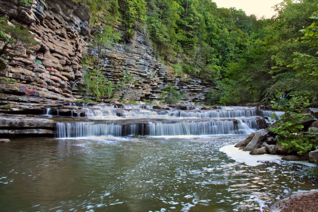
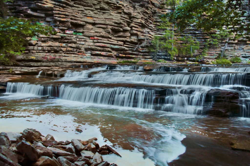
I have explored the Cookeville and Sparta areas many times and had never heard of this waterfall until about a year ago. When I first saw photos of Hardy-Reagan Falls, I thought it was Upper Waterloo Falls. Upon closer examination I realized that while similar in height and width, their backgrounds are very different from each other. Hardy-Reagan Falls has a large cliff background that makes the waterfall even more photogenic.
Hardy-Reagan Falls is between 5-6 feet in height, but is very wide. It has a small “beach” area in front of the waterfall, slightly off to the side. While there I found several small shells in the sand.
Reaching the Waterfall
With very little information about this waterfall, I decided to put in an address that I saw associated with the waterfall into Google Maps – 1634 Standing Stone Highway in Cookeville TN.
To reach the waterfall, leave Cookeville heading north on Standing Stone Highway. Just before you get to Hilham there’s an opening, between guardrails, taking you to the small gravel parking lot. The parking area is located right before the Hardy-Reagan Bridge.
I will note that the parking lot is gravel and had not been graded recently when we visited. This meant there were some holes and deep dips, but if you drive carefully you shouldn’t have any issues.
At the back of the parking area the guardrail ends next to the trailhead. Walk a short distance down the wide trail and you will come to a fork in the trail. Go to your left. The trail becomes rockier the closer you come toward the waterfall, but they are easy to navigate. You will pass a few metal barrels filled with concrete right by the water’s edge. If you go to the left the trail will take you alongside the falls. We passed a large fallen tree along the way, but it was easy to walk around.
Continue further down the trail and there are several places you can cut over to the “beach” area in front of the waterfall. The path directly in front of the waterfall is a little rocky, but pretty easy to navigate.
This is an out-and-back trail, so you’ll return the way you came. The trail is short, probably less than a half mile round trip and easy to navigate.
The Waterfall
Although short in height, it makes up for it in length. The rocky cliff behind the waterfall is tall and interesting to look at. The cliff adds dimension to the waterfall and sets Hardy-Reagan Falls apart from the many other waterfalls with this shape.
There are several large rocks in front of the waterfall so you can get right down in front of it and get a nice photo.
The waterfall is family friendly as it would be easy, even for your little ones to get to it. When we visited, we were fortunate to have the waterfall all to ourselves. It’s a great place to relax in nature, just a short drive outside of downtown Cookeville.
The Surrounding Area
Unfortunately, this is a case of where the waterfall’s beauty has been marred by humans who have visited. Graffiti could be seen not only on the steel barrels mentioned above, but also on the rock face opposite the waterfall. We also saw litter along the bank of the river by the waterfall.
This is a good reminder of why you should remember to take away anything you bring in so that other can enjoy it, and also, so you don’t negatively effect the natural habitat.
Nearby Waterfalls and Attractions
Waterloo Falls and Upper Waterloo Falls – Waterloo Falls is a 35 foot waterfall and Upper Waterloo Falls is a wide, 5 foot waterfall. Waterloo Falls is a great swimming area in the summer. Both waterfalls are located on private property, so if you want to visit them you’ll need to purchase a pass. Cost is $6 per individual or you can get a carpool pass for $24 which covers 4 or more. You can purchase passes at https://waterloovenueandevents.com/river-access/. Parking is only in designated areas.
Burgess Falls – Burgess Falls State Park is home to Burgess Falls and three other (Falling Water Cascades, Little/Upper Falls, and Middle Falls) waterfalls on the same trail. The first waterfall, Falling Water Cascades, is located just steps away from the parking lot. It’s about 20 feet. Little/Upper Falls, the second waterfall on the trail, is 30 feet. The remains of a pipeline bridge that used to cross the river into a tunnel on the north wall of the gorge is visible above Upper Falls. A short distance after you pass Little/Upper Falls you’ll come to a steep staircase. There is a bench at the top of the stairs before you continue on to Middle Falls, an 80 foot waterfall. Continue down the trail to the 136 foot Burgess Falls, the main attraction. There will be a sign by Middle Falls, pointing the direction to Burgess Falls. Continue to follow the trail to the Burgess Falls overlook.
If you go to the ADA overlook you’ll see Little/Upper Falls. Many people say the overlook takes you to Burgess Falls, but that is incorrect. If you just want to see Burgess Falls, the easiest way is to walk down the road past the overlook where you’ll come to a sign for Burgess Falls. Take the stairs down to the bottom and you’ll reach the overlook for Burgess Falls.
City Lake Falls is located inside the City Lake Natural Area in Cookeville. This park and the trail to the waterfall is family friendly. The hike to City Lake Falls is an easy 0.6 mile round trip. The parking area is located next to a beautiful lake. You’ll see the trail that leads you to the waterfall toward the back of the parking area. About half of the trail is paved and then turns to gravel. The trail dead ends into City Lake Falls. While you’re there you may want to enjoy the lake or go fishing.
Leave a Reply